Randonnée Marche Rochefort-en-Valdaine - Le Colombier Montjoyer Citelle Rochefort 19km - Photo

Le Colombier Montjoyer Citelle Rochefort 19km

 thonyc
thonyc

Utilisateur GUIDE

© OpenStreetMap contributors
Longueur
Longueur
18,9 km
Altitude max
Altitude max
434 m
Dénivelé positif
Dénivelé positif
532 m
Km-Effort
Km-Effort  
26 km
Altitude min
Altitude min
215 m
Dénivelé négatif
Dénivelé négatif
532 m
Boucle
Boucle
Oui
Date de création :
2021-01-29 17:10:39.781
Dernière modification :
2021-02-04 08:15:14.437

(0 Avis)

Marche
Marche
5h40
Difficulté : Difficile

Scannez ce code QR pour ouvrir la randonnée dans l'application SityTrail

Application GPS de randonnée GRATUITE

Logo SityTrail SityTrail

IGN / Instituts géographiques

Télécharger SityTrail sur l'App Store Télécharger SityTrail sur Google Play

Logo SityTrail SityTrail World

Le monde est à vous

Télécharger SityTrail sur l'App Store Télécharger SityTrail sur Google Play Télécharger SityTrail sur Huawei AppGallery

À propos

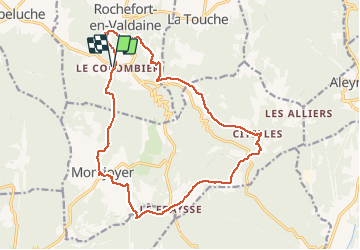
Randonnée Marche de 18,9 km à découvrir à Auvergne-Rhône-Alpes, Drôme, Rochefort-en-Valdaine. Cette randonnée est proposée par thonyc.

Profil altimétrique

Photos

Localisation

Pays :
France
Région :
Auvergne-Rhône-Alpes
Département/Province :
Drôme
Commune :
Rochefort-en-Valdaine
Localité :
Unknown
Départ:(UTM)
647649 ; 4929454 (31T) N.

Randonnées à proximité

Randonnée Marche Portes-en-Valdaine - Portes en Valdaine la plaine 7km - Photo
Marche
GUIDE
thonyc

Marche

Facile
(1)
Portes-en-Valdaine, Auvergne-Rhône-Alpes, Drôme, France
7,1 km | 8,2 km-effort
2h 0min
Oui
Randonnée Marche Allan - allan transclavienne rac - Photo
Marche
micheleuvrard

Marche

Très facile
(1)
Allan, Auvergne-Rhône-Alpes, Drôme, France
19,1 km | 26 km-effort
5h 11min
Oui
Randonnée Marche Portes-en-Valdaine - Portes-en-Valdaine Serre-de-Mirabel 11km. - Photo
Marche
chancha

Marche

Difficile
(1)
Portes-en-Valdaine, Auvergne-Rhône-Alpes, Drôme, France
10,8 km | 14,7 km-effort
3h 20min
Oui
Randonnée V.T.T. Puygiron - Puygiron VTT n°5 - Photo
V.T.T.
tracegps

V.T.T.

Très difficile
(1)
Puygiron, Auvergne-Rhône-Alpes, Drôme, France
47 km | 60 km-effort
3h 0min
Oui
Randonnée Marche La Touche - Citelles hameau et ruisseaux 10km - Photo
Marche
GUIDE
thonyc

Marche

Facile
(2)
La Touche, Auvergne-Rhône-Alpes, Drôme, France
9,6 km | 12,6 km-effort
3h 7min
Oui
Randonnée sport Allan - SityTrail - Les Villages Perchés. - Photo
sport
collot

sport

Très facile
(1)
Allan, Auvergne-Rhône-Alpes, Drôme, France
19,5 km | 27 km-effort
Inconnu
Oui
Randonnée Marche Montboucher-sur-Jabron - 20240428 Rando vieux  - Photo
Marche
Havani

Marche

Très facile
Montboucher-sur-Jabron, Auvergne-Rhône-Alpes, Drôme, France
6,1 km | 6,5 km-effort
5h 17min
Oui
Randonnée Marche Rochefort-en-Valdaine - Rochefort en Valdaine 7,5km - Photo
Marche
GUIDE
thonyc

Marche

Facile
Rochefort-en-Valdaine, Auvergne-Rhône-Alpes, Drôme, France
7,3 km | 10,3 km-effort
2h 30min
Oui
Randonnée Marche Réauville - Abbaye d’Aiguebelle  - Photo
Marche
alinetpierre

Marche

Facile
Réauville, Auvergne-Rhône-Alpes, Drôme, France
13,8 km | 17,9 km-effort
3h 17min
Non


Fermer
Mes abonnements