Randonnée Marche Trancault - Trancault rando linéaire - Photo

Trancault rando linéaire

 Jean CORBERON
Jean CORBERON

Utilisateur

© OpenStreetMap contributors
Longueur
Longueur
26 km
Altitude max
Altitude max
135 m
Dénivelé positif
Dénivelé positif
147 m
Km-Effort
Km-Effort  
28 km
Altitude min
Altitude min
87 m
Dénivelé négatif
Dénivelé négatif
116 m
Boucle
Boucle
Non
Date de création :
2021-01-29 17:10:47.582
Dernière modification :
2021-01-29 17:11:48.607

(0 Avis)

Marche
Marche
6h18
Difficulté : Très difficile

Scannez ce code QR pour ouvrir la randonnée dans l'application SityTrail

Application GPS de randonnée GRATUITE

Logo SityTrail SityTrail

IGN / Instituts géographiques

Télécharger SityTrail sur l'App Store Télécharger SityTrail sur Google Play

Logo SityTrail SityTrail World

Le monde est à vous

Télécharger SityTrail sur l'App Store Télécharger SityTrail sur Google Play Télécharger SityTrail sur Huawei AppGallery

À propos

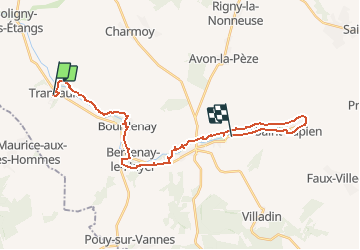
Randonnée Marche de 26 km à découvrir à Grand Est, Aube, Trancault. Cette randonnée est proposée par Jean CORBERON.

Description

Parcours linéaire prévu en mars 2021

Profil altimétrique

Localisation

Pays :
France
Région :
Grand Est
Département/Province :
Aube
Commune :
Trancault
Localité :
Unknown
Départ:(UTM)
539800 ; 5357865 (31U) N.

Randonnées à proximité

Randonnée Marche Saint-Maurice-aux-Riches-Hommes - Forêt de Vauluisant (Dolmens de Trainel + Grotte) - Photo
Marche
Daneel-89

Marche

Facile
(1)
Saint-Maurice-aux-Riches-Hommes, Bourgogne-Franche-Comté, Yonne, France
6,5 km | 8 km-effort
2h 0min
Oui
Randonnée Marche Saint-Maurice-aux-Riches-Hommes - forêt Vauluisant  - Photo
Marche
Domi1956

Marche

Très difficile
Saint-Maurice-aux-Riches-Hommes, Bourgogne-Franche-Comté, Yonne, France
17,3 km | 21 km-effort
5h 38min
Oui


Fermer
Mes abonnements