


St léger

adamfv
Utilisateur
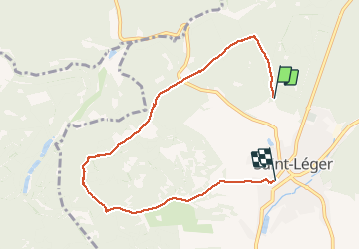

Longueur
6,8 km

Altitude max
350 m

Dénivelé positif
97 m
Km-Effort
8,3 km

Altitude min
259 m

Dénivelé négatif
137 m
Boucle
Non
Date de création :
2021-02-21 10:05:52.0
Dernière modification :
2021-02-21 11:42:38.416
1h34
Difficulté : Inconnu

Application GPS de randonnée GRATUITE
 SityTrail
IGN / Instituts géographiques
SityTrail Plus
Le monde est à vous
À propos
Randonnée Marche de 6,8 km à découvrir à Wallonie, Luxembourg, Saint-Léger. Cette randonnée est proposée par adamfv.
Localisation
Pays :
Belgique
Région :
Wallonie
Département/Province :
Luxembourg
Commune :
Saint-Léger
Localité :
Saint-Léger
Départ:(Dec)
Départ:(UTM)
691662 ; 5499839 (31U) N.
Commentaires