


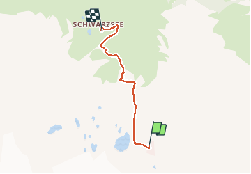
Snowshoes downhill from Trockener Steg to Schwarzsee

seghth
Utilisateur

Longueur
4 km

Altitude max
2928 m

Dénivelé positif
150 m
Km-Effort
7,2 km

Altitude min
2424 m

Dénivelé négatif
495 m
Boucle
Non
Date de création :
2021-02-21 12:43:07.475
Dernière modification :
2021-02-21 14:25:56.126
1h20
Difficulté : Très facile

Application GPS de randonnée GRATUITE
 SityTrail
IGN / Instituts géographiques
SityTrail Plus
Le monde est à vous
À propos
Randonnée Marche de 4 km à découvrir à Valais, Viège, Zermatt. Cette randonnée est proposée par seghth.
Description
. During wind tempest, everything closed
Localisation
Pays :
Suisse
Région :
Valais
Département/Province :
Viège
Commune :
Zermatt
Localité :
Unknown
Départ:(Dec)
Départ:(UTM)
400971 ; 5091662 (32T) N.
Commentaires