


2021-03-24 Nonnnenhardt hardt

maureengeorges
Utilisateur
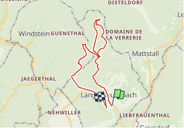

Longueur
13,9 km

Altitude max
393 m

Dénivelé positif
348 m
Km-Effort
18,5 km

Altitude min
188 m

Dénivelé négatif
321 m
Boucle
Non
Date de création :
2021-03-24 13:07:50.517
Dernière modification :
2021-03-24 15:43:17.642
2h34
Difficulté : Facile

Application GPS de randonnée GRATUITE
 SityTrail
IGN / Instituts géographiques
SityTrail Plus
Le monde est à vous
À propos
Randonnée Randonnée équestre de 13,9 km à découvrir à Grand Est, Bas-Rhin, Langensoultzbach. Cette randonnée est proposée par maureengeorges.
Localisation
Pays :
France
Région :
Grand Est
Département/Province :
Bas-Rhin
Commune :
Langensoultzbach
Localité :
Unknown
Départ:(Dec)
Départ:(UTM)
407519 ; 5424142 (32U) N.
Commentaires