Randonnée Randonnée équestre Stosswihr - 2021-03-03 WE Orbey Cascades Stolz Ablass Stosswihr - Photo

2021-03-03 WE Orbey Cascades Stolz Ablass Stosswihr

 holtzv
holtzv

Utilisateur GUIDE

© OpenStreetMap contributors
Longueur
Longueur
22 km
Altitude max
Altitude max
997 m
Dénivelé positif
Dénivelé positif
809 m
Km-Effort
Km-Effort  
32 km
Altitude min
Altitude min
454 m
Dénivelé négatif
Dénivelé négatif
809 m
Boucle
Boucle
Oui
Date de création :
2021-03-30 09:51:42.894
Dernière modification :
2021-03-30 09:59:05.237

(0 Avis)

Randonnée équestre
Randonnée équestre
4h15
Difficulté : Difficile

Scannez ce code QR pour ouvrir la randonnée dans l'application SityTrail

Application GPS de randonnée GRATUITE

Logo SityTrail SityTrail

IGN / Instituts géographiques

Télécharger SityTrail sur l'App Store Télécharger SityTrail sur Google Play

Logo SityTrail SityTrail World

Le monde est à vous

Télécharger SityTrail sur l'App Store Télécharger SityTrail sur Google Play Télécharger SityTrail sur Huawei AppGallery

À propos

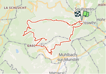
Randonnée Randonnée équestre de 22 km à découvrir à Grand Est, Haut-Rhin, Stosswihr. Cette randonnée est proposée par holtzv.

Description

Boucle depuis Stosswihr en passant par :
- Cascades Stolz Ablass
- Tourbière sous le Gaschney
- Gaschney
- Altmattkopf
- Col du Sattel

Profil altimétrique

Points d'intérêt

Point d'intérêt Stosswihr - Table de Pique-Nique - Photo
holtzv
Point d'intérêt Stosswihr - Cascades Stolz Ablass - Photo
holtzv
Point d'intérêt Stosswihr - Fontaine - Photo
holtzv
STOSSWIHR 

Localisation

Pays :
France
Région :
Grand Est
Département/Province :
Haut-Rhin
Commune :
Stosswihr
Localité :
Unknown
Départ:(UTM)
358459 ; 5324025 (32U) N.

Randonnées à proximité

Randonnée Marche Stosswihr - Tour du belvedere avec le passage sur les crêtes  - Photo
Marche
ocepee

Marche

Très facile
(2)
Stosswihr, Grand Est, Haut-Rhin, France
8,5 km | 0 m-effort
2h 28min
Oui
Randonnée Autre activité Soultzeren - Totom 4 lacs - Photo
Autre activité
dinozore

Autre activité

Moyen
(1)
Soultzeren, Grand Est, Haut-Rhin, France
15,6 km | 26 km-effort
4h 37min
Oui
Randonnée Marche Munster - De Munster aux 3 Fours (Aller) - Munster - Photo
Marche
tracegps

Marche

Difficile
(1)
Munster, Grand Est, Haut-Rhin, France
14,8 km | 27 km-effort
5h 0min
Non
Randonnée Marche Hohrod - Circuit historique 1914-18 Hohrodberg - Linge - Photo
Marche
VacheKiri67

Marche

Moyen
(1)
Hohrod, Grand Est, Haut-Rhin, France
14 km | 19,8 km-effort
5h 50min
Oui
Randonnée Marche Munster - 19.06.13.Munster  - Photo
Marche
ROPPJP

Marche

Très facile
(1)
Munster, Grand Est, Haut-Rhin, France
7,3 km | 10,6 km-effort
2h 10min
Oui
Randonnée Marche Soultzeren - Tanet-Gazon du faing par lac vert et retour sommet du Tanet - Photo
Marche
ride-in-Elsass

Marche

Moyen
(1)
Soultzeren, Grand Est, Haut-Rhin, France
10 km | 15,6 km-effort
4h 24min
Oui
Randonnée V.T.T. Metzeral - Sentier des Névés - Photo
V.T.T.
tracegps

V.T.T.

Très difficile
(1)
Metzeral, Grand Est, Haut-Rhin, France
33 km | 52 km-effort
6h 0min
Oui
Randonnée Randonnée équestre Gunsbach - Le petit Hohnack - verkort (23) - Photo
Randonnée équestre
eddyvermeulen1

Randonnée équestre

Facile
(1)
Gunsbach, Grand Est, Haut-Rhin, France
13,1 km | 18,4 km-effort
2h 25min
Oui
Randonnée Marche Soultzeren - 2022-12-27 Marche Soultzeren Lac Forlet Hautes Huttes Glasborn - Photo
Marche
GUIDE
holtzv

Marche

Très difficile
Soultzeren, Grand Est, Haut-Rhin, France
21 km | 34 km-effort
5h 47min
Oui


Fermer
Mes abonnements