


2021-03-30 Trotting

maureengeorges
Utilisateur
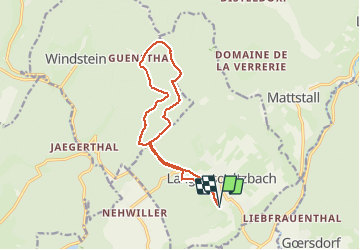

Longueur
12,7 km

Altitude max
372 m

Dénivelé positif
278 m
Km-Effort
16,4 km

Altitude min
211 m

Dénivelé négatif
278 m
Boucle
Oui
Date de création :
2021-03-30 11:46:27.978
Dernière modification :
2021-03-30 14:10:41.108
2h23
Difficulté : Facile

Application GPS de randonnée GRATUITE
 SityTrail
IGN / Instituts géographiques
SityTrail Plus
Le monde est à vous
À propos
Randonnée Randonnée équestre de 12,7 km à découvrir à Grand Est, Bas-Rhin, Langensoultzbach. Cette randonnée est proposée par maureengeorges.
Localisation
Pays :
France
Région :
Grand Est
Département/Province :
Bas-Rhin
Commune :
Langensoultzbach
Localité :
Unknown
Départ:(Dec)
Départ:(UTM)
407296 ; 5423939 (32U) N.
Commentaires