Randonnée Geocaching Argences - 1#Les hauteurs d'Argences - Photo

1#Les hauteurs d'Argences

 yannick-p
yannick-p

Utilisateur

© OpenStreetMap contributors
Longueur
Longueur
4,2 km
Altitude max
Altitude max
72 m
Dénivelé positif
Dénivelé positif
28 m
Km-Effort
Km-Effort  
4,6 km
Altitude min
Altitude min
59 m
Dénivelé négatif
Dénivelé négatif
28 m
Boucle
Boucle
Oui
Date de création :
2021-04-15 20:43:53.921
Dernière modification :
2021-06-04 10:01:28.403

(0 Avis)

Geocaching
Geocaching
2h00
Difficulté : Facile

Scannez ce code QR pour ouvrir la randonnée dans l'application SityTrail

Application GPS de randonnée GRATUITE

Logo SityTrail SityTrail

IGN / Instituts géographiques

Télécharger SityTrail sur l'App Store Télécharger SityTrail sur Google Play

Logo SityTrail SityTrail World

Le monde est à vous

Télécharger SityTrail sur l'App Store Télécharger SityTrail sur Google Play Télécharger SityTrail sur Huawei AppGallery

À propos

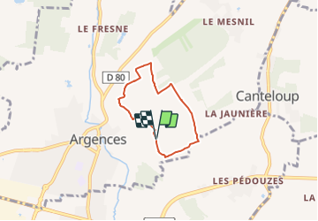
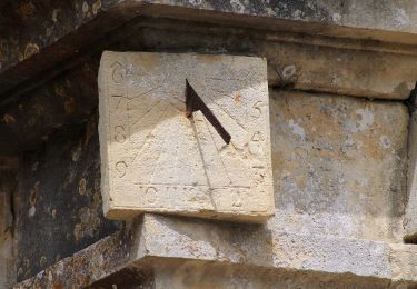
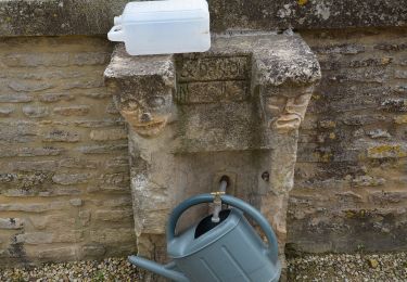
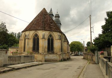
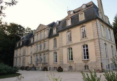
Randonnée Geocaching de 4,2 km à découvrir à Normandie, Calvados, Argences. Cette randonnée est proposée par yannick-p.

Description

Petit circuit de géocaching de 20 caches.

Profil altimétrique

Localisation

Pays :
France
Région :
Normandie
Département/Province :
Calvados
Commune :
Argences
Localité :
Unknown
Départ:(UTM)
707715 ; 5445478 (30U) N.

Randonnées à proximité

Randonnée Marche Saint-Ouen-du-Mesnil-Oger - st ouen du mesnil oger - Photo
Marche
nono1425

Marche

Très facile
(1)
Saint-Ouen-du-Mesnil-Oger, Normandie, Calvados, France
5,1 km | 5,5 km-effort
1h 20min
Non
Randonnée Marche nordique Moult-Chicheboville - 02b-moult-bois saint- gilles - Photo
Marche nordique
phi14

Marche nordique

Très facile
(1)
Moult-Chicheboville, Normandie, Calvados, France
8,7 km | 10 km-effort
Inconnu
Oui
Randonnée A pied Argences - Les Crêtes d'Argences - Photo
A pied
PRO

A pied

Facile
Argences, Normandie, Calvados, France
6 km | 7,1 km-effort
1h 37min
Oui
Randonnée A pied Argences - Les Sentes de l'Avant Côte d'Auge - Photo
A pied
PRO

A pied

Facile
Argences, Normandie, Calvados, France
4,5 km | 5,3 km-effort
1h 12min
Non
Randonnée A pied Argences - Vignes et Bruyères - Photo
A pied
PRO

A pied

Facile
Argences, Normandie, Calvados, France
15,9 km | 17,8 km-effort
4h 2min
Oui
Randonnée A pied Méry-Bissières-en-Auge - Vignes et Pommiers - Photo
A pied
PRO

A pied

Facile
Méry-Bissières-en-Auge, Normandie, Calvados, France
9,5 km | 10,8 km-effort
2h 27min
Oui
Randonnée A pied Mézidon Vallée d'Auge - Vignes et Pommiers - Photo
A pied
PRO

A pied

Facile
Mézidon Vallée d'Auge, Normandie, Calvados, France
6,9 km | 8,3 km-effort
1h 53min
Oui
Randonnée A pied Valambray - Bois, Vignes, Champs et Prés - Photo
A pied
PRO

A pied

Moyen
Valambray, Normandie, Calvados, France
20 km | 23 km-effort
5h 15min
Oui
Randonnée A pied Valambray - La Tour de Valmeray et la Muance - Photo
A pied
PRO

A pied

Facile
Valambray, Normandie, Calvados, France
11,7 km | 12,7 km-effort
2h 53min
Oui


Fermer
Mes abonnements