Randonnée Marche Villeneuve-de-Marc - 20210423 - Photo
 GALIBER
GALIBER

Utilisateur

© OpenStreetMap contributors
Longueur
Longueur
15 km
Altitude max
Altitude max
470 m
Dénivelé positif
Dénivelé positif
349 m
Km-Effort
Km-Effort  
19,6 km
Altitude min
Altitude min
322 m
Dénivelé négatif
Dénivelé négatif
350 m
Boucle
Boucle
Oui
Date de création :
2021-04-01 15:38:51.423
Dernière modification :
2021-04-25 07:01:58.107

(0 Avis)

Marche
Marche
4h00
Difficulté : Très difficile

Scannez ce code QR pour ouvrir la randonnée dans l'application SityTrail

Application GPS de randonnée GRATUITE

Logo SityTrail SityTrail

IGN / Instituts géographiques

Télécharger SityTrail sur l'App Store Télécharger SityTrail sur Google Play

Logo SityTrail SityTrail World

Le monde est à vous

Télécharger SityTrail sur l'App Store Télécharger SityTrail sur Google Play Télécharger SityTrail sur Huawei AppGallery

À propos

Randonnée Marche de 15 km à découvrir à Auvergne-Rhône-Alpes, Isère, Villeneuve-de-Marc. Cette randonnée est proposée par GALIBER.

Profil altimétrique

Photos

Localisation

Pays :
France
Région :
Auvergne-Rhône-Alpes
Département/Province :
Isère
Commune :
Villeneuve-de-Marc
Localité :
Unknown
Départ:(UTM)
664408 ; 5037781 (31T) N.

Randonnées à proximité

Randonnée A pied Meyssiez - Meyssiez - 10,7 km - 297 m de dénivelé - 3h30 - Photo
A pied
Clubléorando

A pied

Moyen
Meyssiez, Auvergne-Rhône-Alpes, Isère, France
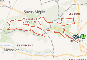
10,7 km | 14,7 km-effort
3h 30min
Oui
Randonnée Marche Beauvoir-de-Marc - beauvoir - Photo
Marche
Bataillon

Marche

Très difficile
Beauvoir-de-Marc, Auvergne-Rhône-Alpes, Isère, France
14,8 km | 20 km-effort
4h 33min
Oui
Randonnée Vélo de route Savas-Mépin - 38 vienne vélo gg - Photo
Vélo de route
himba26100

Vélo de route

Facile
Savas-Mépin, Auvergne-Rhône-Alpes, Isère, France
49 km | 62 km-effort
6h 30min
Oui
Randonnée V.T.T. Saint-Jean-de-Bournay - Essai  - Photo
V.T.T.
Jocelyn Derville

V.T.T.

Moyen
Saint-Jean-de-Bournay, Auvergne-Rhône-Alpes, Isère, France
18,7 km | 22 km-effort
1h 20min
Oui
Randonnée Marche Savas-Mépin - Savas Beauvoir la madone - Photo
Marche
Nad38

Marche

Facile
Savas-Mépin, Auvergne-Rhône-Alpes, Isère, France
10 km | 12,5 km-effort
2h 15min
Oui
Randonnée Marche Saint-Jean-de-Bournay - 1/07 - Photo
Marche
GALIBER

Marche

Très facile
Saint-Jean-de-Bournay, Auvergne-Rhône-Alpes, Isère, France
5,1 km | 7,6 km-effort
1h 39min
Non
Randonnée Marche Saint-Jean-de-Bournay - Chapelle St Hugon - Photo
Marche
yvos38

Marche

Très facile
Saint-Jean-de-Bournay, Auvergne-Rhône-Alpes, Isère, France
3,8 km | 4,8 km-effort
1h 2min
Oui
Randonnée Marche Saint-Julien-de-l'Herms - Foret de Bonneavax - Photo
Marche
parazon

Marche

Très facile
Saint-Julien-de-l'Herms, Auvergne-Rhône-Alpes, Isère, France
5,7 km | 6,7 km-effort
1h 0min
Oui
Randonnée Marche Saint-Jean-de-Bournay - st jean l'etang de mont joux  - Photo
Marche
phil1178

Marche

Facile
Saint-Jean-de-Bournay, Auvergne-Rhône-Alpes, Isère, France
10,1 km | 11,9 km-effort
2h 43min
Non


Fermer
Mes abonnements