


deb machy-sgmo

ophness
Utilisateur
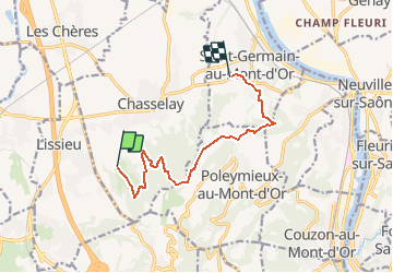

Longueur
9,2 km

Altitude max
495 m

Dénivelé positif
308 m
Km-Effort
13,5 km

Altitude min
235 m

Dénivelé négatif
375 m
Boucle
Non
Date de création :
2021-05-04 09:54:09.673
Dernière modification :
2021-05-04 09:54:31.161
1h46
Difficulté : Facile

Application GPS de randonnée GRATUITE
 SityTrail
IGN / Instituts géographiques
SityTrail Plus
Le monde est à vous
À propos
Randonnée Randonnée équestre de 9,2 km à découvrir à Auvergne-Rhône-Alpes, Rhône, Chasselay. Cette randonnée est proposée par ophness.
Localisation
Pays :
France
Région :
Auvergne-Rhône-Alpes
Département/Province :
Rhône
Commune :
Chasselay
Localité :
Unknown
Départ:(Dec)
Départ:(UTM)
636696 ; 5080035 (31T) N.
Commentaires