Randonnée Marche Morville-sur-Seille - Morville-sur-Seille, Eply, Raucourt 15 650m +153m - Photo

Morville-sur-Seille, Eply, Raucourt 15 650m +153m

 DanielROLLET
DanielROLLET

Utilisateur

© OpenStreetMap contributors
Longueur
Longueur
15,6 km
Altitude max
Altitude max
242 m
Dénivelé positif
Dénivelé positif
153 m
Km-Effort
Km-Effort  
17,7 km
Altitude min
Altitude min
174 m
Dénivelé négatif
Dénivelé négatif
153 m
Boucle
Boucle
Oui
Date de création :
2021-05-07 07:30:07.728
Dernière modification :
2021-05-08 07:42:37.279

(0 Avis)

Marche
Marche
4h30
Difficulté : Difficile

Scannez ce code QR pour ouvrir la randonnée dans l'application SityTrail

Application GPS de randonnée GRATUITE

Logo SityTrail SityTrail

IGN / Instituts géographiques

Télécharger SityTrail sur l'App Store Télécharger SityTrail sur Google Play

Logo SityTrail SityTrail World

Le monde est à vous

Télécharger SityTrail sur l'App Store Télécharger SityTrail sur Google Play Télécharger SityTrail sur Huawei AppGallery

À propos

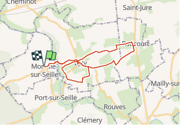
Randonnée Marche de 15,6 km à découvrir à Grand Est, Meurthe-et-Moselle, Morville-sur-Seille. Cette randonnée est proposée par DanielROLLET.

Description

2021 05 07 Reco balisage pour Rando 54 avec Marie.
Beau temps mais venteux et frais.
9h30 à 14h00

Profil altimétrique

Localisation

Pays :
France
Région :
Grand Est
Département/Province :
Meurthe-et-Moselle
Commune :
Morville-sur-Seille
Localité :
Unknown
Départ:(UTM)
291638 ; 5422145 (32U) N.

Randonnées à proximité

Randonnée Marche Belleau - Manoncourt sur seille  - Photo
Marche
jean-marie.parachini

Marche

Facile
Belleau, Grand Est, Meurthe-et-Moselle, France
9,5 km | 11,1 km-effort
4h 3min
Oui
Randonnée Marche Lesménils - Lesmenils - Le Xon - Photo
Marche
jean-marie.parachini

Marche

Facile
Lesménils, Grand Est, Meurthe-et-Moselle, France
5 km | 6,9 km-effort
2h 10min
Oui
Randonnée Marche Éply - SC3 Circuit les Prés Bas 4 500m + 39m - Photo
Marche
DanielROLLET

Marche

Facile
Éply, Grand Est, Meurthe-et-Moselle, France
4,7 km | 5,3 km-effort
1h 3min
Oui
Randonnée Marche Bouxières-sous-Froidmont - Bouxières sous Froidmont - Photo
Marche
joelclaudel

Marche

Difficile
Bouxières-sous-Froidmont, Grand Est, Meurthe-et-Moselle, France
19,3 km | 26 km-effort
5h 26min
Oui
Randonnée V.T.C. Cheminot - Sort avec lola - Photo
V.T.C.
meon

V.T.C.

Facile
Cheminot, Grand Est, Moselle, France
8,6 km | 9,3 km-effort
49min
Oui
Randonnée V.T.T. Cheminot - Autour de Cheminot  - Photo
V.T.T.
meon

V.T.T.

Très difficile
Cheminot, Grand Est, Moselle, France
44 km | 52 km-effort
3h 29min
Non
Randonnée Marche Lesménils - Xon - Lesmenils  - Photo
Marche
JeanPierreNancy

Marche

Moyen
Lesménils, Grand Est, Meurthe-et-Moselle, France
11,7 km | 15,9 km-effort
3h 36min
Oui
Randonnée Marche Lesménils - Xon et forêt de Facq - Photo
Marche
jean-marie.parachini

Marche

Difficile
(1)
Lesménils, Grand Est, Meurthe-et-Moselle, France
10,3 km | 13,2 km-effort
3h 0min
Oui
Randonnée Marche Éply - SC1 Circuit des anciens bois 7 090m +65m - Photo
Marche
DanielROLLET

Marche

Moyen
Éply, Grand Est, Meurthe-et-Moselle, France
7,1 km | 8 km-effort
1h 48min
Oui


Fermer
Mes abonnements