


Ucimont Het graf van de Reus Botassart - 9 km RT

wandelroutes
Utilisateur
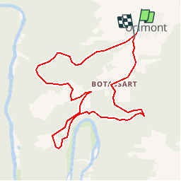

Longueur
9 km

Altitude max
374 m

Dénivelé positif
336 m
Km-Effort
13,5 km

Altitude min
220 m

Dénivelé négatif
334 m
Boucle
Oui
Date de création :
2014-12-10 00:00:00.0
Dernière modification :
2014-12-10 00:00:00.0
--
Difficulté : Inconnu

Application GPS de randonnée GRATUITE
 SityTrail
IGN / Instituts géographiques
SityTrail Plus
Le monde est à vous
À propos
Randonnée Marche de 9 km à découvrir à Wallonie, Luxembourg, Bouillon. Cette randonnée est proposée par wandelroutes.
Description
More information on : http://www.wandelroutes.org


Localisation
Pays :
Belgique
Région :
Wallonie
Département/Province :
Luxembourg
Commune :
Bouillon
Localité :
Ucimont
Départ:(Dec)
Départ:(UTM)
647797 ; 5521817 (31U) N.
Commentaires
Heel mooie wandeling met leuke uitzichtpunten. Veel schaduw maar in het begin wel moeilijk begaanbaar door de vele struiken met doorns.