


2021-05-20 Langensoultzbach-Nonnenhardt-Col de Wineckerthal-Col de Guensthal-Langensoultzbach

maureengeorges
Utilisateur
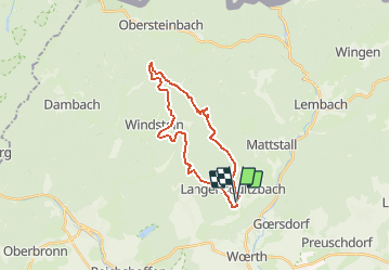

Longueur
22 km

Altitude max
477 m

Dénivelé positif
529 m
Km-Effort
29 km

Altitude min
187 m

Dénivelé négatif
527 m
Boucle
Oui
Date de création :
2021-05-20 07:38:10.031
Dernière modification :
2021-05-20 07:39:56.866
3h47
Difficulté : Moyen

Application GPS de randonnée GRATUITE
 SityTrail
IGN / Instituts géographiques
SityTrail Plus
Le monde est à vous
À propos
Randonnée Randonnée équestre de 22 km à découvrir à Grand Est, Bas-Rhin, Langensoultzbach. Cette randonnée est proposée par maureengeorges.
Localisation
Pays :
France
Région :
Grand Est
Département/Province :
Bas-Rhin
Commune :
Langensoultzbach
Localité :
Unknown
Départ:(Dec)
Départ:(UTM)
407512 ; 5424106 (32U) N.
Commentaires