


VALENCIN 16.06.21

6ARVAL7
Utilisateur
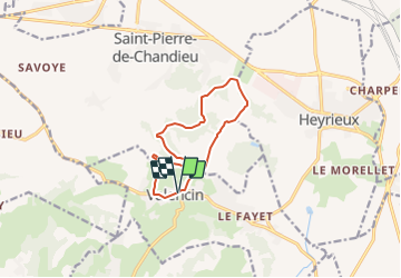

Longueur
11 km

Altitude max
366 m

Dénivelé positif
251 m
Km-Effort
14,3 km

Altitude min
273 m

Dénivelé négatif
249 m
Boucle
Oui
Date de création :
2021-05-31 16:53:39.255
Dernière modification :
2021-05-31 16:54:36.207
3h15
Difficulté : Difficile

Application GPS de randonnée GRATUITE
 SityTrail
IGN / Instituts géographiques
SityTrail Plus
Le monde est à vous
À propos
Randonnée Marche de 11 km à découvrir à Auvergne-Rhône-Alpes, Isère, Valencin. Cette randonnée est proposée par 6ARVAL7.
Localisation
Pays :
France
Région :
Auvergne-Rhône-Alpes
Département/Province :
Isère
Commune :
Valencin
Localité :
Unknown
Départ:(Dec)
Départ:(UTM)
657284 ; 5053037 (31T) N.
Commentaires