


Vercors Sentier Gobert et Col Vert

c.gourme
Utilisateur
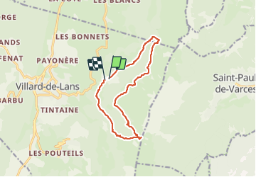

Longueur
13,7 km

Altitude max
1746 m

Dénivelé positif
664 m
Km-Effort
23 km

Altitude min
1163 m

Dénivelé négatif
686 m
Boucle
Oui
Date de création :
2021-06-01 08:51:12.0
Dernière modification :
2021-06-01 15:01:08.909
5h47
Difficulté : Moyen

Application GPS de randonnée GRATUITE
 SityTrail
IGN / Instituts géographiques
SityTrail Plus
Le monde est à vous
À propos
Randonnée Marche de 13,7 km à découvrir à Auvergne-Rhône-Alpes, Isère, Villard-de-Lans. Cette randonnée est proposée par c.gourme.
Description
Réfléchir ds quel sens le faire : parking col vert 2 h / 1h en descente
Localisation
Pays :
France
Région :
Auvergne-Rhône-Alpes
Département/Province :
Isère
Commune :
Villard-de-Lans
Localité :
Unknown
Départ:(Dec)
Départ:(UTM)
703187 ; 4994305 (31T) N.
Commentaires