


ST JACQUES

surceneux
Utilisateur
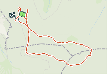

Longueur
5,5 km

Altitude max
1093 m

Dénivelé positif
125 m
Km-Effort
7,2 km

Altitude min
1002 m

Dénivelé négatif
129 m
Boucle
Oui
Date de création :
2021-06-12 09:24:08.565
Dernière modification :
2021-06-12 17:38:45.207
1h15
Difficulté : Très facile

Application GPS de randonnée GRATUITE
 SityTrail
IGN / Instituts géographiques
SityTrail Plus
Le monde est à vous
À propos
Randonnée Marche de 5,5 km à découvrir à Grand Est, Vosges, Xonrupt-Longemer. Cette randonnée est proposée par surceneux.
Description
FONTAINE FERRY ST JACQUES BOUCLE PISTES FOND
Localisation
Pays :
France
Région :
Grand Est
Département/Province :
Vosges
Commune :
Xonrupt-Longemer
Localité :
Unknown
Départ:(Dec)
Départ:(UTM)
344625 ; 5325429 (32U) N.
Commentaires