


Moustier

vinwee
Utilisateur
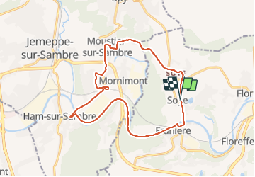

Longueur
14,9 km

Altitude max
122 m

Dénivelé positif
151 m
Km-Effort
16,9 km

Altitude min
80 m

Dénivelé négatif
149 m
Boucle
Oui
Date de création :
2021-06-14 16:48:55.219
Dernière modification :
2021-06-14 21:52:37.807
1h08
Difficulté : Facile

Application GPS de randonnée GRATUITE
 SityTrail
IGN / Instituts géographiques
SityTrail Plus
Le monde est à vous
À propos
Randonnée V.T.C. de 14,9 km à découvrir à Wallonie, Namur, Floreffe. Cette randonnée est proposée par vinwee.
Localisation
Pays :
Belgique
Région :
Wallonie
Département/Province :
Namur
Commune :
Floreffe
Localité :
Soye
Départ:(Dec)
Départ:(UTM)
622978 ; 5590036 (31U) N.
Commentaires