Randonnée V.T.T. Virton - Montquintin et Villers-la-Loue - Balade_VTT_19Kms - Photo

Montquintin et Villers-la-Loue - Balade_VTT_19Kms

 Pascal L
Pascal L

Utilisateur

© OpenStreetMap contributors
Longueur
Longueur
19,1 km
Altitude max
Altitude max
318 m
Dénivelé positif
Dénivelé positif
360 m
Km-Effort
Km-Effort  
24 km
Altitude min
Altitude min
192 m
Dénivelé négatif
Dénivelé négatif
361 m
Boucle
Boucle
Oui
Date de création :
2021-06-18 16:06:29.502
Dernière modification :
2022-08-31 12:44:22.202

(0 Avis)

V.T.T.
V.T.T.
2h00
Difficulté : Moyen

Scannez ce code QR pour ouvrir la randonnée dans l'application SityTrail

Application GPS de randonnée GRATUITE

Logo SityTrail SityTrail

IGN / Instituts géographiques

Télécharger SityTrail sur l'App Store Télécharger SityTrail sur Google Play

Logo SityTrail SityTrail World

Le monde est à vous

Télécharger SityTrail sur l'App Store Télécharger SityTrail sur Google Play Télécharger SityTrail sur Huawei AppGallery

À propos

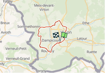
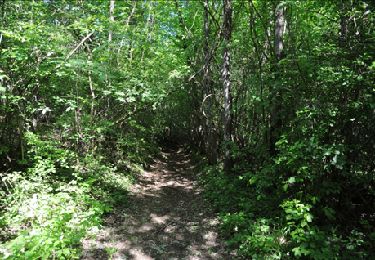
Randonnée V.T.T. de 19,1 km à découvrir à Wallonie, Luxembourg, Virton. Cette randonnée est proposée par Pascal L.

Description

Départ/Retour : Saint-Mard (le stade)

Endroits de passage : Usine Burgo, Harnoncourt, Montquintin (par la côte Trûche Gilliot), Couvreux, Bois de Dampicourt, Bois d'Arrentement, Villers-la-Loue, Houdrigny, Vieux-Virton

Ref.
- https://rouvroy.be/presentation/178/le-village-de-montquintin
- https://www.meix-devant-virton.be/ma-commune/decouvrir/historique/villers-la-loue
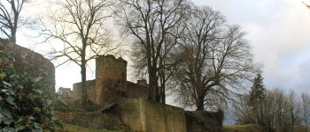
- https://www.luxembourg-belge.be/diffusio/fr/voir-faire/visiter/chateaux-monuments/montquintin/ruines-du-chateau-de-montquintin-patrimoine-majeur-de-wallonie_TFO12339.php
- https://rouvroy.be/presentation/52/le-village-de-couvreux

(2021.06.18)

Profil altimétrique

Photos

Points d'intérêt

Point d'intérêt Virton - Golf Découverte Virton - Photo
Pascal L

Localisation

Pays :
Belgique
Région :
Wallonie
Département/Province :
Luxembourg
Commune :
Virton
Localité :
Unknown
Départ:(UTM)
682220 ; 5491972 (31U) N.

Randonnées à proximité

Randonnée Marche Virton - RB-Lu-17_Ethe_via-var-1-et-2-et-3 - Photo
Marche
PRO

Marche

Très facile
(3)
Virton, Wallonie, Luxembourg, Belgique
29 km | 35 km-effort
7h 33min
Oui
Randonnée Marche Rouvroy - Torgny. Natura 2000, des sites qui valent le détour. Lx5 - Photo
Marche
GUIDE+

Marche

Moyen
(3)
Rouvroy, Wallonie, Luxembourg, Belgique
7,5 km | 11 km-effort
2h 18min
Oui
Randonnée V.T.T. Virton - Autour de Ethe  -  Balade_VTT_20kms - Photo
V.T.T.
Pascal L

V.T.T.

Facile
(1)
Virton, Wallonie, Luxembourg, Belgique
21 km | 26 km-effort
1h 40min
Oui
Randonnée A pied Virton - Chenois-Latour Boucle agricole et touristique - Entre villages, pommes et petits fruits - Photo
A pied
GUIDE
DUPONT Rita

A pied

Facile
Virton, Wallonie, Luxembourg, Belgique
6,4 km | 7,7 km-effort
1h 45min
Oui
Randonnée Marche Virton - RB-Lu-17_Ethe_via-racc - Photo
Marche
PRO

Marche

Très facile
Virton, Wallonie, Luxembourg, Belgique
15,6 km | 19,3 km-effort
4h 8min
Oui
Randonnée Marche Virton - RB-Lu-17_Ethe - Photo
Marche
PRO

Marche

Très facile
Virton, Wallonie, Luxembourg, Belgique
22 km | 28 km-effort
5h 55min
Oui
Randonnée Cheval Rouvroy - rallye 2014 - Photo
Cheval
christianegabriel

Cheval

Moyen
(1)
Rouvroy, Wallonie, Luxembourg, Belgique
26 km | 32 km-effort
4h 1min
Oui
Randonnée V.T.T. Virton - Autour de Tintigny  -  Balade_VTT_54Kms - Photo
V.T.T.
Pascal L

V.T.T.

Très difficile
Virton, Wallonie, Luxembourg, Belgique
54 km | 64 km-effort
4h 25min
Oui
Randonnée V.T.T. Virton - Monquintin  -  Balade_VTT_22Kms - Photo
V.T.T.
Pascal L

V.T.T.

Moyen
Virton, Wallonie, Luxembourg, Belgique
22 km | 26 km-effort
1h 48min
Oui


Fermer
Mes abonnements