


La Bérarde/source du Vénéon version longue

geoffrayLayeux
Utilisateur
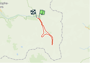

Longueur
17 km

Altitude max
2160 m

Dénivelé positif
630 m
Km-Effort
25 km

Altitude min
1686 m

Dénivelé négatif
657 m
Boucle
Non
Date de création :
2021-06-26 11:21:30.63
Dernière modification :
2021-06-26 11:22:18.506
5h47
Difficulté : Très difficile

Application GPS de randonnée GRATUITE
 SityTrail
IGN / Instituts géographiques
SityTrail Plus
Le monde est à vous
À propos
Randonnée Marche de 17 km à découvrir à Auvergne-Rhône-Alpes, Isère, Saint-Christophe-en-Oisans. Cette randonnée est proposée par geoffrayLayeux.
Localisation
Pays :
France
Région :
Auvergne-Rhône-Alpes
Département/Province :
Isère
Commune :
Saint-Christophe-en-Oisans
Localité :
Unknown
Départ:(Dec)
Départ:(UTM)
286376 ; 4979006 (32T) N.
Commentaires