Randonnée V.T.T. Cuzieu - Cuzieu Vongnes - Photo
 jeannot01
jeannot01

Utilisateur

© OpenStreetMap contributors
Longueur
Longueur
16,4 km
Altitude max
Altitude max
423 m
Dénivelé positif
Dénivelé positif
367 m
Km-Effort
Km-Effort  
21 km
Altitude min
Altitude min
319 m
Dénivelé négatif
Dénivelé négatif
363 m
Boucle
Boucle
Oui
Date de création :
2016-08-03 00:00:00.0
Dernière modification :
2021-08-25 06:46:49.385

(1 Avis)

V.T.T.
V.T.T.
2h05
Difficulté : Moyen

Scannez ce code QR pour ouvrir la randonnée dans l'application SityTrail

Application GPS de randonnée GRATUITE

Logo SityTrail SityTrail

IGN / Instituts géographiques

Télécharger SityTrail sur l'App Store Télécharger SityTrail sur Google Play

Logo SityTrail SityTrail World

Le monde est à vous

Télécharger SityTrail sur l'App Store Télécharger SityTrail sur Google Play Télécharger SityTrail sur Huawei AppGallery

À propos

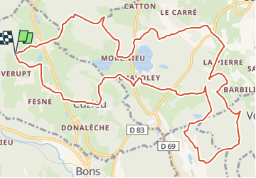
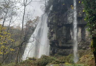
Randonnée V.T.T. de 16,4 km à découvrir à Auvergne-Rhône-Alpes, Ain, Cuzieu. Cette randonnée est proposée par jeannot01.

Description

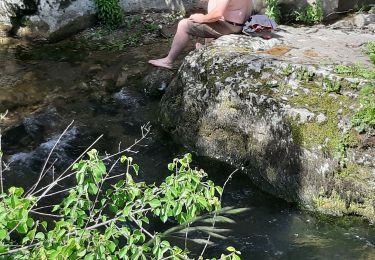
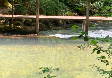
Petit tour entre Cuzieu et Vognes.
Profile varié gros chemin et single.
Pas de difficulté particulière.

Peut être cumulé avec la rando Cuzieu-St Martin.

Profil altimétrique

Localisation

Pays :
France
Région :
Auvergne-Rhône-Alpes
Département/Province :
Ain
Commune :
Cuzieu
Localité :
Unknown
Départ:(Dec)
Départ:(UTM)
707052 ; 5078127 (31T) N.

Randonnées à proximité

Randonnée V.T.T. Andert-et-Condon - Boucle sous Gevrin  - Photo
V.T.T.
sandrine-s01

V.T.T.

Facile
(1)
Andert-et-Condon, Auvergne-Rhône-Alpes, Ain, France
13,1 km | 17,1 km-effort
1h 1min
Oui
Randonnée Marche Virieu-le-Grand - virieu - Cascades de Dard - Photo
Marche
aurel69

Marche

Moyen
(1)
Virieu-le-Grand, Auvergne-Rhône-Alpes, Ain, France
9,2 km | 11,9 km-effort
3h 53min
Oui
Randonnée V.T.T. Andert-et-Condon - Recherche suite chemin du dimanche vers Gramont - Photo
V.T.T.
sandrine-s01

V.T.T.

Très difficile
Andert-et-Condon, Auvergne-Rhône-Alpes, Ain, France
11,6 km | 16,6 km-effort
1h 7min
Oui
Randonnée V.T.T. Andert-et-Condon - Sous Gevrin et Veript - Photo
V.T.T.
sandrine-s01

V.T.T.

Moyen
Andert-et-Condon, Auvergne-Rhône-Alpes, Ain, France
16,7 km | 22 km-effort
1h 28min
Non
Randonnée Marche Cheignieu-la-Balme - cascade de DARD - Photo
Marche
Jacky Fumey

Marche

Très facile
Cheignieu-la-Balme, Auvergne-Rhône-Alpes, Ain, France
25 km | 34 km-effort
1h 32min
Non
Randonnée V.T.T. Andert-et-Condon - Tour 4 - Photo
V.T.T.
sandrine-s01

V.T.T.

Moyen
Andert-et-Condon, Auvergne-Rhône-Alpes, Ain, France
12,6 km | 16,4 km-effort
1h 6min
Oui
Randonnée V.T.T. Andert-et-Condon - Petite sortie vers Sainte Anne - Photo
V.T.T.
sandrine-s01

V.T.T.

Difficile
Andert-et-Condon, Auvergne-Rhône-Alpes, Ain, France
19,4 km | 26 km-effort
2h 50min
Oui
Randonnée Marche Vongnes - 2019-04-30 Vongnes-lac de Chavoley - Photo
Marche
patpounet73

Marche

Moyen
Vongnes, Auvergne-Rhône-Alpes, Ain, France
19,3 km | 25 km-effort
5h 27min
Oui
Randonnée V.T.T. Cheignieu-la-Balme - De Cheignieu à Egieu par Armix - Photo
V.T.T.
sandrine-s01

V.T.T.

Difficile
Cheignieu-la-Balme, Auvergne-Rhône-Alpes, Ain, France
16,7 km | 26 km-effort
2h 10min
Oui


Fermer
Mes abonnements