Randonnée Marche Saint-Jean-de-Thurigneux - St Jean de Thrinueux autour du Camping du Soleil de Lyon - Photo

St Jean de Thrinueux autour du Camping du Soleil de Lyon

 jll7513
jll7513

Utilisateur

© OpenStreetMap contributors
Longueur
Longueur
7,1 km
Altitude max
Altitude max
304 m
Dénivelé positif
Dénivelé positif
41 m
Km-Effort
Km-Effort  
7,7 km
Altitude min
Altitude min
281 m
Dénivelé négatif
Dénivelé négatif
40 m
Boucle
Boucle
Oui
Date de création :
2021-08-12 10:46:44.505
Dernière modification :
2021-08-19 10:58:56.836

(0 Avis)

Marche
Marche
1h44
Difficulté : Facile
Course à pied
Course à pied
46m
Difficulté : Facile

Scannez ce code QR pour ouvrir la randonnée dans l'application SityTrail

Application GPS de randonnée GRATUITE

Logo SityTrail SityTrail

IGN / Instituts géographiques

Télécharger SityTrail sur l'App Store Télécharger SityTrail sur Google Play

Logo SityTrail SityTrail World

Le monde est à vous

Télécharger SityTrail sur l'App Store Télécharger SityTrail sur Google Play Télécharger SityTrail sur Huawei AppGallery

À propos

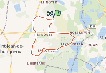
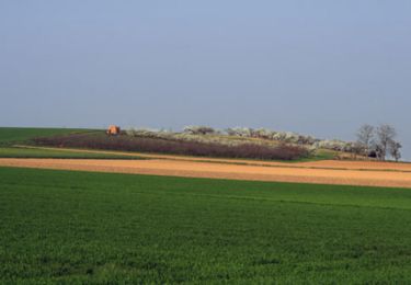
Randonnée Marche de 7,1 km à découvrir à Auvergne-Rhône-Alpes, Ain, Saint-Jean-de-Thurigneux. Cette randonnée est proposée par jll7513.

Description

Petit jogging sympa, dans les 300 derniers mètres, Il y a une barrière sur le chemin, mais c'est un chemin communal, elle n'a pas lieu d'être là, la barrière est fermée avec un cadenas, je suis passé par-dessus. Personne ne m'a rien dit. Et on m'a confirmé ensuite que ce chemin n'était effectivement pas privé.

Profil altimétrique

Localisation

Pays :
France
Région :
Auvergne-Rhône-Alpes
Département/Province :
Ain
Commune :
Saint-Jean-de-Thurigneux
Localité :
Unknown
Départ:(UTM)
647843 ; 5091822 (31T) N.

Randonnées à proximité

Randonnée A pied Monthieux - Observatoire sur l'Étang Grange Volet - Photo
A pied
PRO

A pied

Facile
Monthieux, Auvergne-Rhône-Alpes, Ain, France
7,3 km | 7,9 km-effort
1h 47min
Oui
Randonnée Marche Monthieux - Monthieux-11km-78m - Photo
Marche
ThierryJ01

Marche

Moyen
(2)
Monthieux, Auvergne-Rhône-Alpes, Ain, France
10,9 km | 11,9 km-effort
2h 39min
Oui
Randonnée Marche Savigneux - Savigneux le Fond de Juis Savigneux - Photo
Marche
jll7513

Marche

Très facile
Savigneux, Auvergne-Rhône-Alpes, Ain, France
12,7 km | 14 km-effort
3h 7min
Oui
Randonnée Marche Monthieux - Étangs Monthieux  - Photo
Marche
partner

Marche

Très facile
Monthieux, Auvergne-Rhône-Alpes, Ain, France
5,9 km | 6,3 km-effort
2h 16min
Oui
Randonnée Marche Civrieux -  Le grand tour - Civrieux en Dombes - Photo
Marche
tracegps

Marche

Moyen
(1)
Civrieux, Auvergne-Rhône-Alpes, Ain, France
7,2 km | 8 km-effort
2h 0min
Oui
Randonnée Marche Ambérieux-en-Dombes - Amberieux en Dombes - Photo
Marche
Thomasdanielle

Marche

Facile
Ambérieux-en-Dombes, Auvergne-Rhône-Alpes, Ain, France
18,5 km | 20 km-effort
4h 55min
Oui
Randonnée Vélo Ambérieux-en-Dombes - Amberieux-en-Dombes - Photo
Vélo
doclocjl

Vélo

Très facile
Ambérieux-en-Dombes, Auvergne-Rhône-Alpes, Ain, France
41 km | 45 km-effort
3h 44min
Oui
Randonnée V.T.T. Civrieux - VTT CCSV n° 13 - Photo
V.T.T.
rocho

V.T.T.

Très facile
Civrieux, Auvergne-Rhône-Alpes, Ain, France
7,8 km | 8,8 km-effort
30min
Oui
Randonnée V.T.T. Civrieux - VTT CCSV n° 14 - Photo
V.T.T.
rocho

V.T.T.

Très facile
Civrieux, Auvergne-Rhône-Alpes, Ain, France
8,2 km | 9,5 km-effort
30min
Oui


Fermer
Mes abonnements