


Depuis Mathay direction Goux les Dambelins,Lanthenans,Sourans.Villars sous Ecots et retour

tiene
Utilisateur
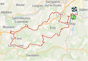

Longueur
52 km

Altitude max
568 m

Dénivelé positif
1248 m
Km-Effort
69 km

Altitude min
319 m

Dénivelé négatif
1253 m
Boucle
Non
Date de création :
2021-09-17 11:35:47.584
Dernière modification :
2021-09-18 13:41:03.752
3h52
Difficulté : Très difficile

Application GPS de randonnée GRATUITE
 SityTrail
IGN / Instituts géographiques
SityTrail Plus
Le monde est à vous
À propos
Randonnée V.T.T. de 52 km à découvrir à Bourgogne-Franche-Comté, Doubs, Mathay. Cette randonnée est proposée par tiene.
Localisation
Pays :
France
Région :
Bourgogne-Franche-Comté
Département/Province :
Doubs
Commune :
Mathay
Localité :
Unknown
Départ:(Dec)
Départ:(UTM)
332646 ; 5256161 (32T) N.
Commentaires