Randonnée Marche Coly-Saint-Amand - Coly boucle du Bouch - Photo
 YV24
YV24

Utilisateur

© OpenStreetMap contributors
Longueur
Longueur
6,1 km
Altitude max
Altitude max
199 m
Dénivelé positif
Dénivelé positif
127 m
Km-Effort
Km-Effort  
7,8 km
Altitude min
Altitude min
106 m
Dénivelé négatif
Dénivelé négatif
127 m
Boucle
Boucle
Oui
Date de création :
2021-10-08 19:45:05.27
Dernière modification :
2021-10-08 19:46:40.032

(0 Avis)

Marche
Marche
1h46
Difficulté : Moyen

Scannez ce code QR pour ouvrir la randonnée dans l'application SityTrail

Application GPS de randonnée GRATUITE

Logo SityTrail SityTrail

IGN / Instituts géographiques

Télécharger SityTrail sur l'App Store Télécharger SityTrail sur Google Play

Logo SityTrail SityTrail World

Le monde est à vous

Télécharger SityTrail sur l'App Store Télécharger SityTrail sur Google Play Télécharger SityTrail sur Huawei AppGallery

À propos

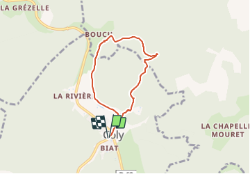
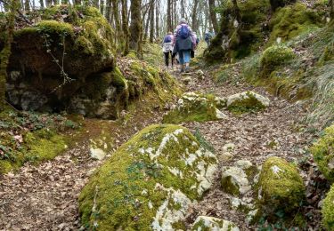
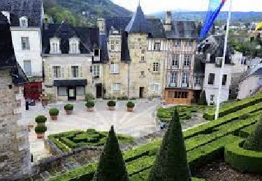
Randonnée Marche de 6,1 km à découvrir à Nouvelle-Aquitaine, Dordogne, Coly-Saint-Amand. Cette randonnée est proposée par YV24.

Description

Selon n°17 du la carte PDIPR de Terrasson
Départ parking mairie de Coly

Profil altimétrique

Localisation

Pays :
France
Région :
Nouvelle-Aquitaine
Département/Province :
Dordogne
Commune :
Coly-Saint-Amand
Localité :
Unknown
Départ:(UTM)
363666 ; 4993899 (31T) N.

Randonnées à proximité

Randonnée Marche La Cassagne - rivière de Coly - Photo
Marche
GuyLab

Marche

Très facile
La Cassagne, Nouvelle-Aquitaine, Dordogne, France
5,4 km | 6,8 km-effort
2h 12min
Oui
Randonnée A pied Condat-sur-Vézère - Boucle de la Commanderie - Photo
A pied
dmortier

A pied

Facile
Condat-sur-Vézère, Nouvelle-Aquitaine, Dordogne, France
9,5 km | 12,6 km-effort
2h 20min
Oui
Randonnée Marche Terrasson-Lavilledieu - Terrasson-Boucle de la Vézère - Photo
Marche
houbart

Marche

Facile
(1)
Terrasson-Lavilledieu, Nouvelle-Aquitaine, Dordogne, France
11,4 km | 12,9 km-effort
2h 48min
Oui
Randonnée Marche Coly-Saint-Amand - vezere_19 - Photo
Marche
fanthou

Marche

Moyen
(3)
Coly-Saint-Amand, Nouvelle-Aquitaine, Dordogne, France
8,2 km | 11,1 km-effort
2h 22min
Oui
Randonnée Marche Coly-Saint-Amand - coly300322 - Photo
Marche
Reider

Marche

Difficile
Coly-Saint-Amand, Nouvelle-Aquitaine, Dordogne, France
11,4 km | 14,5 km-effort
3h 22min
Oui
Randonnée Marche Terrasson-Lavilledieu - Boucle de Maneyrol - Photo
Marche
CC.RIDER

Marche

Très difficile
Terrasson-Lavilledieu, Nouvelle-Aquitaine, Dordogne, France
16,6 km | 24 km-effort
5h 23min
Oui
Randonnée Marche Terrasson-Lavilledieu - Boucle du Bouch - Photo
Marche
CC.RIDER

Marche

Difficile
(1)
Terrasson-Lavilledieu, Nouvelle-Aquitaine, Dordogne, France
11,5 km | 16,4 km-effort
3h 43min
Oui
Randonnée Marche Coly-Saint-Amand - Saint Amand de Coly  - Photo
Marche
alainjoseph6

Marche

Facile
Coly-Saint-Amand, Nouvelle-Aquitaine, Dordogne, France
1,6 km | 2,4 km-effort
1h 17min
Oui
Randonnée Marche Coly-Saint-Amand - aiOn- - Photo
Marche
Galandos

Marche

Moyen
Coly-Saint-Amand, Nouvelle-Aquitaine, Dordogne, France
5,5 km | 7,1 km-effort
2h 2min
Oui


Fermer
Mes abonnements