


trimathlon

PatriceCocuaud
Utilisateur
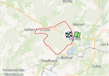

Longueur
21 km

Altitude max
404 m

Dénivelé positif
386 m
Km-Effort
27 km

Altitude min
254 m

Dénivelé négatif
390 m
Boucle
Oui
Date de création :
2021-10-22 09:19:34.841
Dernière modification :
2021-10-22 11:34:59.293
2h15
Difficulté : Facile

Application GPS de randonnée GRATUITE
 SityTrail
IGN / Instituts géographiques
SityTrail Plus
Le monde est à vous
À propos
Randonnée V.T.T. de 21 km à découvrir à Bourgogne-Franche-Comté, Haute-Saône, Esprels. Cette randonnée est proposée par PatriceCocuaud.
Localisation
Pays :
France
Région :
Bourgogne-Franche-Comté
Département/Province :
Haute-Saône
Commune :
Esprels
Localité :
Unknown
Départ:(Dec)
Départ:(UTM)
302029 ; 5267513 (32T) N.
Commentaires