


VTT(13)-Tour-la-ciotat

HG74250
Utilisateur
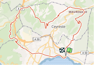

Longueur
31 km

Altitude max
450 m

Dénivelé positif
947 m
Km-Effort
43 km

Altitude min
2 m

Dénivelé négatif
941 m
Boucle
Oui
Date de création :
2021-10-27 18:19:21.717
Dernière modification :
2021-10-27 18:38:46.726
2h59
Difficulté : Très difficile

Application GPS de randonnée GRATUITE
 SityTrail
IGN / Instituts géographiques
SityTrail Plus
Le monde est à vous
À propos
Randonnée V.T.T. de 31 km à découvrir à Provence-Alpes-Côte d'Azur, Bouches-du-Rhône, La Ciotat. Cette randonnée est proposée par HG74250.
Description
Petit tour Ciotaden...............................
Localisation
Pays :
France
Région :
Provence-Alpes-Côte d'Azur
Département/Province :
Bouches-du-Rhône
Commune :
La Ciotat
Localité :
Unknown
Départ:(Dec)
Départ:(UTM)
715262 ; 4785318 (31T) N.
Commentaires