


THOARD . Les Hauts Cognets o n l ?

RobinMicheline
Utilisateur GUIDE
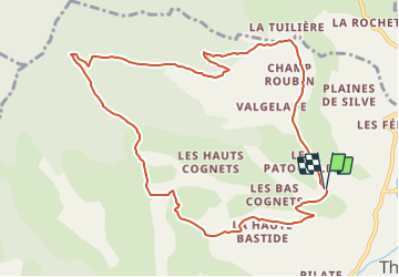

Longueur
11,3 km

Altitude max
1352 m

Dénivelé positif
592 m
Km-Effort
19,2 km

Altitude min
776 m

Dénivelé négatif
592 m
Boucle
Oui
Date de création :
2021-11-01 13:42:30.052
Dernière modification :
2021-11-02 18:14:45.878
4h21
Difficulté : Très difficile

Application GPS de randonnée GRATUITE
 SityTrail
IGN / Instituts géographiques
SityTrail Plus
Le monde est à vous
À propos
Randonnée Marche de 11,3 km à découvrir à Provence-Alpes-Côte d'Azur, Alpes-de-Haute-Provence, Thoard. Cette randonnée est proposée par RobinMicheline.
Localisation
Pays :
France
Région :
Provence-Alpes-Côte d'Azur
Département/Province :
Alpes-de-Haute-Provence
Commune :
Thoard
Localité :
Unknown
Départ:(Dec)
Départ:(UTM)
270926 ; 4893465 (32T) N.
Commentaires