


Le broussan- Signes

caroline83150
Utilisateur

Longueur
19,6 km

Altitude max
781 m

Dénivelé positif
569 m
Km-Effort
27 km

Altitude min
298 m

Dénivelé négatif
533 m
Boucle
Non
Date de création :
2021-11-05 08:35:15.0
Dernière modification :
2021-11-05 14:58:24.07
6h22
Difficulté : Très difficile

Application GPS de randonnée GRATUITE
 SityTrail
IGN / Instituts géographiques
SityTrail Plus
Le monde est à vous
À propos
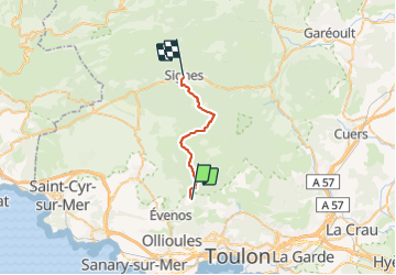
Randonnée Marche de 19,6 km à découvrir à Provence-Alpes-Côte d'Azur, Var, Évenos. Cette randonnée est proposée par caroline83150.
Description
Beau parcours , chemin facile avec de sympathiques sous bois . Champignons
Localisation
Pays :
France
Région :
Provence-Alpes-Côte d'Azur
Département/Province :
Var
Commune :
Évenos
Localité :
Unknown
Départ:(Dec)
Départ:(UTM)
733594 ; 4784501 (31T) N.
Commentaires