


Profondeville/Arbre

geoffrayLayeux
Utilisateur
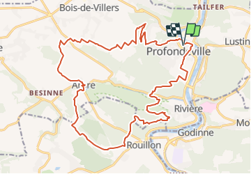

Longueur
23 km

Altitude max
274 m

Dénivelé positif
696 m
Km-Effort
32 km

Altitude min
79 m

Dénivelé négatif
696 m
Boucle
Oui
Date de création :
2021-11-22 19:11:00.955
Dernière modification :
2021-11-22 19:11:58.85
7h20
Difficulté : Très difficile

Application GPS de randonnée GRATUITE
 SityTrail
IGN / Instituts géographiques
SityTrail Plus
Le monde est à vous
À propos
Randonnée Marche de 23 km à découvrir à Wallonie, Namur, Profondeville. Cette randonnée est proposée par geoffrayLayeux.
Localisation
Pays :
Belgique
Région :
Wallonie
Département/Province :
Namur
Commune :
Profondeville
Localité :
Profondeville
Départ:(Dec)
Départ:(UTM)
632944 ; 5582317 (31U) N.
Commentaires