


Chassant 19.09

togolo28
Utilisateur
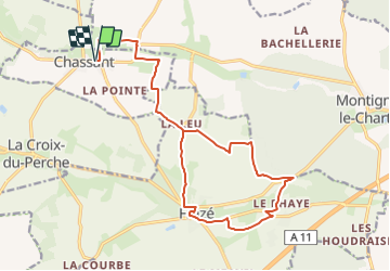

Longueur
19,2 km

Altitude max
218 m

Dénivelé positif
160 m
Km-Effort
21 km

Altitude min
175 m

Dénivelé négatif
160 m
Boucle
Oui
Date de création :
2021-11-28 15:21:06.284
Dernière modification :
2022-02-12 15:42:24.335
--
Difficulté : Moyen

Application GPS de randonnée GRATUITE
 SityTrail
IGN / Instituts géographiques
SityTrail Plus
Le monde est à vous
À propos
Randonnée Marche de 19,2 km à découvrir à Centre-Val de Loire, Eure-et-Loir, Chassant. Cette randonnée est proposée par togolo28.
Localisation
Pays :
France
Région :
Centre-Val de Loire
Département/Province :
Eure-et-Loir
Commune :
Chassant
Localité :
Unknown
Départ:(Dec)
Départ:(UTM)
356683 ; 5350885 (31U) N.
Commentaires