Randonnée Marche Seillans - Le lac de Meaulx - Photo
 boulinevelyne
boulinevelyne

Utilisateur

© OpenStreetMap contributors
Longueur
Longueur
10,8 km
Altitude max
Altitude max
288 m
Dénivelé positif
Dénivelé positif
215 m
Km-Effort
Km-Effort  
13,7 km
Altitude min
Altitude min
187 m
Dénivelé négatif
Dénivelé négatif
216 m
Boucle
Boucle
Oui
Date de création :
2021-11-30 08:29:13.626
Dernière modification :
2021-11-30 15:27:13.151

(0 Avis)

Marche
Marche
2h26
Difficulté : Moyen

Scannez ce code QR pour ouvrir la randonnée dans l'application SityTrail

Application GPS de randonnée GRATUITE

Logo SityTrail SityTrail

IGN / Instituts géographiques

Télécharger SityTrail sur l'App Store Télécharger SityTrail sur Google Play

Logo SityTrail SityTrail World

Le monde est à vous

Télécharger SityTrail sur l'App Store Télécharger SityTrail sur Google Play Télécharger SityTrail sur Huawei AppGallery

À propos

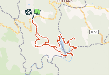
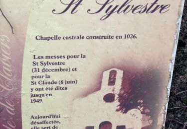
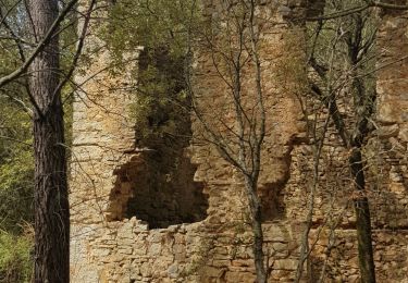
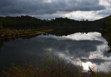
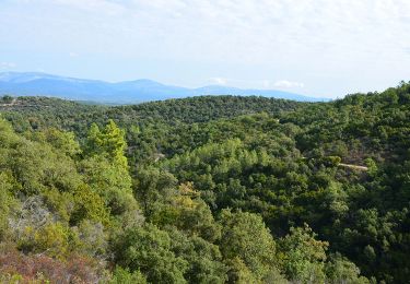
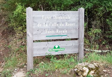
Randonnée Marche de 10,8 km à découvrir à Provence-Alpes-Côte d'Azur, Var, Seillans. Cette randonnée est proposée par boulinevelyne.

Description

Rando facile  mais une seule difficulté de passage au niveau du barrage ou il faut etre prudent .

Profil altimétrique

Photos

Localisation

Pays :
France
Région :
Provence-Alpes-Côte d'Azur
Département/Province :
Var
Commune :
Seillans
Localité :
Unknown
Départ:(UTM)
308075 ; 4828019 (32T) N.

Randonnées à proximité

Randonnée Marche Callas - gorge de Penafore - Photo
Marche
marmotte83

Marche

Très facile
(1)
Callas, Provence-Alpes-Côte d'Azur, Var, France
1,1 km | 1,3 km-effort
1h 33min
Oui
Randonnée Marche Callas - La catalane ,Font Blanche, les Cabanons - Photo
Marche
boulinevelyne

Marche

Moyen
(1)
Callas, Provence-Alpes-Côte d'Azur, Var, France
10,3 km | 14,2 km-effort
3h 19min
Oui
Randonnée Marche Claviers - Claviers - St Arnoux - Photo
Marche
ETMU5496

Marche

Moyen
Claviers, Provence-Alpes-Côte d'Azur, Var, France
18 km | 26 km-effort
4h 2min
Oui
Randonnée Marche Seillans - La Pigne - Photo
Marche
avdem

Marche

Facile
Seillans, Provence-Alpes-Côte d'Azur, Var, France
16,3 km | 23 km-effort
5h 51min
Oui
Randonnée Marche Fayence - St Paul en Forêt - Lac de Méaulx - Pont de l'Endre - Piste Colle Douce - Photo
Marche
LtZIP

Marche

Facile
Fayence, Provence-Alpes-Côte d'Azur, Var, France
16,9 km | 22 km-effort
5h 32min
Oui
Randonnée Marche Saint-Paul-en-Forêt - Saint Paul en Forêt - Lac de Méaulx - Photo
Marche
LtZIP

Marche

Moyen
(1)
Saint-Paul-en-Forêt, Provence-Alpes-Côte d'Azur, Var, France
14,8 km | 19,3 km-effort
4h 7min
Oui
Randonnée Marche Bagnols-en-Forêt - SAINT PAUL EN FORÊT - VERS LE LAC DE MEAULX - Photo
Marche
jean-marie.parachini

Marche

Moyen
Bagnols-en-Forêt, Provence-Alpes-Côte d'Azur, Var, France
14,8 km | 18,1 km-effort
5h 15min
Oui
Randonnée Marche Seillans - Meaulx 2 rando du lac - Photo
Marche
Sugg

Marche

Très facile
Seillans, Provence-Alpes-Côte d'Azur, Var, France
19,9 km | 26 km-effort
7h 5min
Oui
Randonnée Marche Seillans - Meaulx 2 le lac - Photo
Marche
Sugg

Marche

Facile
Seillans, Provence-Alpes-Côte d'Azur, Var, France
20 km | 26 km-effort
5h 35min
Oui


Fermer
Mes abonnements