


89.019 Walferdange - Luxembourg

ADL339
Utilisateur
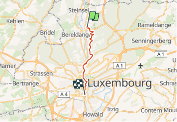

Longueur
9,8 km

Altitude max
352 m

Dénivelé positif
324 m
Km-Effort
14 km

Altitude min
237 m

Dénivelé négatif
274 m
Boucle
Non
Date de création :
2021-12-12 17:34:07.0
Dernière modification :
2021-12-12 17:34:08.572
3h10
Difficulté : Moyen

Application GPS de randonnée GRATUITE
 SityTrail
IGN / Instituts géographiques
SityTrail Plus
Le monde est à vous
À propos
Randonnée Marche de 9,8 km à découvrir à Inconnu, Canton Luxembourg, Walferdange. Cette randonnée est proposée par ADL339.
Localisation
Pays :
Luxembourg
Région :
Inconnu
Département/Province :
Canton Luxembourg
Commune :
Walferdange
Localité :
Unknown
Départ:(Dec)
Départ:(UTM)
293340 ; 5504989 (32U) N.
Commentaires