Randonnée Marche Chamagnieu - Autour de Mianges - Photo
 Elaan4
Elaan4

Utilisateur

© OpenStreetMap contributors
Longueur
Longueur
9,1 km
Altitude max
Altitude max
304 m
Dénivelé positif
Dénivelé positif
185 m
Km-Effort
Km-Effort  
11,5 km
Altitude min
Altitude min
218 m
Dénivelé négatif
Dénivelé négatif
184 m
Boucle
Boucle
Non
Date de création :
2022-01-02 13:55:09.0
Dernière modification :
2022-01-02 16:44:03.013

(0 Avis)

Marche
Marche
2h48
Difficulté : Moyen

Scannez ce code QR pour ouvrir la randonnée dans l'application SityTrail

Application GPS de randonnée GRATUITE

Logo SityTrail SityTrail

IGN / Instituts géographiques

Télécharger SityTrail sur l'App Store Télécharger SityTrail sur Google Play

Logo SityTrail SityTrail World

Le monde est à vous

Télécharger SityTrail sur l'App Store Télécharger SityTrail sur Google Play Télécharger SityTrail sur Huawei AppGallery

À propos

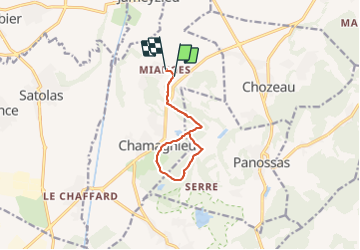
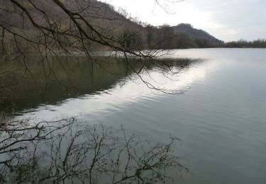
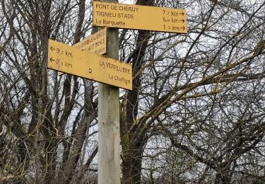
Randonnée Marche de 9,1 km à découvrir à Auvergne-Rhône-Alpes, Isère, Chamagnieu. Cette randonnée est proposée par Elaan4.

Description

Mianges - le chatrou - mont Morel -chamagnieu

Profil altimétrique

Localisation

Pays :
France
Région :
Auvergne-Rhône-Alpes
Département/Province :
Isère
Commune :
Chamagnieu
Localité :
Unknown
Départ:(Dec)
Départ:(UTM)
669379 ; 5062716 (31T) N.

Randonnées à proximité

Randonnée V.T.T. Veyssilieu - Le Dauphin de l'Isle d'Abeau 2008 - 35 kms - Photo
V.T.T.
tracegps

V.T.T.

Difficile
(2)
Veyssilieu, Auvergne-Rhône-Alpes, Isère, France
34 km | 43 km-effort
2h 30min
Oui
Randonnée V.T.T. Crémieu - Voie verte Crémieu Arandon - Photo
V.T.T.
SyMA

V.T.T.

Très facile
Crémieu, Auvergne-Rhône-Alpes, Isère, France
41 km | 45 km-effort
3h 11min
Oui
Randonnée V.T.T. Chamagnieu - Rando des Etangs - Chamagnieu   - Photo
V.T.T.
tracegps

V.T.T.

Moyen
Chamagnieu, Auvergne-Rhône-Alpes, Isère, France
26 km | 35 km-effort
2h 30min
Oui
Randonnée V.T.T. Chamagnieu - Autour de Chamagnieu - Photo
V.T.T.
tracegps

V.T.T.

Difficile
Chamagnieu, Auvergne-Rhône-Alpes, Isère, France
29 km | 36 km-effort
2h 30min
Oui
Randonnée Marche Chamagnieu - Autour de Chamagnieu - Photo
Marche
tracegps

Marche

Difficile
Chamagnieu, Auvergne-Rhône-Alpes, Isère, France
29 km | 36 km-effort
5h 30min
Oui
Randonnée Marche Satolas-et-Bonce - chauffard  - Photo
Marche
cricri34

Marche

Facile
Satolas-et-Bonce, Auvergne-Rhône-Alpes, Isère, France
3,9 km | 4,3 km-effort
57min
Non
Randonnée Marche Tignieu-Jameyzieu - La Tignieulande - Photo
Marche
cricri34

Marche

Très facile
Tignieu-Jameyzieu, Auvergne-Rhône-Alpes, Isère, France
9,2 km | 10,2 km-effort
1h 57min
Oui
Randonnée Marche Chozeau - muguet reconnu le 250419 - Photo
Marche
lydiaodile

Marche

Très facile
Chozeau, Auvergne-Rhône-Alpes, Isère, France
4 km | 5,7 km-effort
1h 36min
Oui
Randonnée sport Villemoirieu - Villeroi - Photo
sport
pzvictor

sport

Très facile
Villemoirieu, Auvergne-Rhône-Alpes, Isère, France
9,7 km | 13,2 km-effort
Inconnu
Oui


Fermer
Mes abonnements