Randonnée Marche Saint-Christophe-en-Oisans - 2 La Bérarde-Tête de la Maye-La Bérarde-Refuge Temple Ecrin - Photo

2 La Bérarde-Tête de la Maye-La Bérarde-Refuge Temple Ecrin

 edouard_bieber
edouard_bieber

Utilisateur

© OpenStreetMap contributors
Longueur
Longueur
11,3 km
Altitude max
Altitude max
2504 m
Dénivelé positif
Dénivelé positif
1498 m
Km-Effort
Km-Effort  
29 km
Altitude min
Altitude min
1708 m
Dénivelé négatif
Dénivelé négatif
805 m
Boucle
Boucle
Non
Date de création :
2022-02-06 09:52:08.727
Dernière modification :
2023-09-10 15:31:24.62

(0 Avis)

Marche
Marche
6h35
Difficulté : Très difficile

Scannez ce code QR pour ouvrir la randonnée dans l'application SityTrail

Application GPS de randonnée GRATUITE

Logo SityTrail SityTrail

IGN / Instituts géographiques

Télécharger SityTrail sur l'App Store Télécharger SityTrail sur Google Play

Logo SityTrail SityTrail World

Le monde est à vous

Télécharger SityTrail sur l'App Store Télécharger SityTrail sur Google Play Télécharger SityTrail sur Huawei AppGallery

À propos

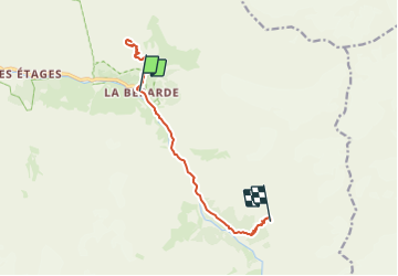
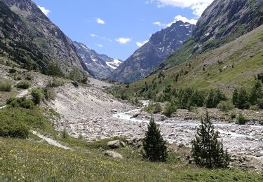
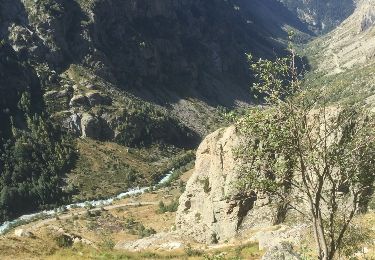
Randonnée Marche de 11,3 km à découvrir à Auvergne-Rhône-Alpes, Isère, Saint-Christophe-en-Oisans. Cette randonnée est proposée par edouard_bieber.

Description

2ème jour rando Vénéon

Profil altimétrique

Localisation

Pays :
France
Région :
Auvergne-Rhône-Alpes
Département/Province :
Isère
Commune :
Saint-Christophe-en-Oisans
Localité :
Unknown
Départ:(UTM)
286301 ; 4979059 (32T) N.

Randonnées à proximité

Randonnée Marche Saint-Christophe-en-Oisans - Rando depart du refuge du Carrelet et arrivée à La Berarde - Photo
Marche
HF89

Marche

Facile
Saint-Christophe-en-Oisans, Auvergne-Rhône-Alpes, Isère, France
4,4 km | 5,3 km-effort
1h 10min
Non
Randonnée Marche Saint-Christophe-en-Oisans - Malraux Refuge du Chateleret - Photo
Marche
rapako

Marche

Facile
Saint-Christophe-en-Oisans, Auvergne-Rhône-Alpes, Isère, France
12,1 km | 19,4 km-effort
5h 26min
Oui
Randonnée Marche Saint-Christophe-en-Oisans - Saint-Christophe-en-Oisans - Vallon des Etages - 6.5km 375m 3h20 - 2018 06 19 - Photo
Marche
Orcal37

Marche

Moyen
Saint-Christophe-en-Oisans, Auvergne-Rhône-Alpes, Isère, France
6,3 km | 11,2 km-effort
3h 20min
Oui
Randonnée Marche Saint-Christophe-en-Oisans - Saint-Christophe-en-Oisans - La Bérarde Cotillat (le Châtelleret) - 10.7km 390m 5h30 (45mn) - 2018 06 22 - Photo
Marche
Orcal37

Marche

Moyen
Saint-Christophe-en-Oisans, Auvergne-Rhône-Alpes, Isère, France
10,8 km | 16 km-effort
5h 30min
Oui
Randonnée Marche Saint-Christophe-en-Oisans - REFUGE DE CHATELLERET depuis LA BERARDE-07-09-2016 - Photo
Marche
RD78-38

Marche

Facile
Saint-Christophe-en-Oisans, Auvergne-Rhône-Alpes, Isère, France
14,9 km | 25 km-effort
6h 30min
Oui
Randonnée Marche Saint-Christophe-en-Oisans - MONTÉE vers LE REFUGE DU SOREILLER-08-09-2016 - Photo
Marche
RD78-38

Marche

Moyen
Saint-Christophe-en-Oisans, Auvergne-Rhône-Alpes, Isère, France
5,6 km | 16,9 km-effort
4h 5min
Non
Randonnée Marche Saint-Christophe-en-Oisans - RETOUR du REFUGE DU SOREILLER-09-09-2016 - Photo
Marche
RD78-38

Marche

Moyen
Saint-Christophe-en-Oisans, Auvergne-Rhône-Alpes, Isère, France
5,6 km | 9,6 km-effort
3h 2min
Non
Randonnée Marche Saint-Christophe-en-Oisans - Saint-Christophe-en-Oisans - Vallée du Vénéon les Etages - 5.2km 170m 3h15 - 2015 06 25 - Photo
Marche
Orcal37

Marche

Facile
Saint-Christophe-en-Oisans, Auvergne-Rhône-Alpes, Isère, France
5,2 km | 7,6 km-effort
3h 15min
Oui
Randonnée Marche Saint-Christophe-en-Oisans - Saint-Christophe-en-Oisans - La Bérarde Refuge du Carrelet - 7.9km 220m 2h50 - 2015 06 20 - Photo
Marche
Orcal37

Marche

Moyen
Saint-Christophe-en-Oisans, Auvergne-Rhône-Alpes, Isère, France
7,9 km | 10,8 km-effort
2h 50min
Oui


Fermer
Mes abonnements