Randonnée A pied Oy-Mittelberg - Steinmeile - Photo

Tous les sentiers balisés d’Europe PRO

© OpenStreetMap contributors
Longueur
Longueur
8,2 km
Altitude max
Altitude max
1094 m
Dénivelé positif
Dénivelé positif
178 m
Km-Effort
Km-Effort  
10,6 km
Altitude min
Altitude min
927 m
Dénivelé négatif
Dénivelé négatif
177 m
Boucle
Boucle
Oui
Balise
Balise
Date de création :
2022-02-11 13:58:28.739
Dernière modification :
2022-02-11 13:58:28.739

(0 Avis)

A pied
A pied
2h23
Difficulté : Facile

Scannez ce code QR pour ouvrir la randonnée dans l'application SityTrail

Application GPS de randonnée GRATUITE

Logo SityTrail SityTrail

IGN / Instituts géographiques

Télécharger SityTrail sur l'App Store Télécharger SityTrail sur Google Play

Logo SityTrail SityTrail World

Le monde est à vous

Télécharger SityTrail sur l'App Store Télécharger SityTrail sur Google Play Télécharger SityTrail sur Huawei AppGallery

À propos

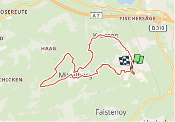
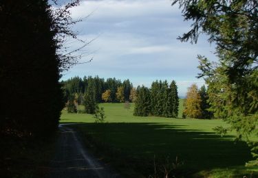
Randonnée A pied de 8,2 km à découvrir à Bavière, Landkreis Oberallgäu, Oy-Mittelberg. Cette randonnée est proposée par SityTrail - itinéraires balisés pédestres.

Description

Randonnée créée par Deutscher Alpenverein Sektion Oy/Allgäu.

Symbole: Rundes schwarz-weißes Landschaftslogo

Photos

Localisation

Pays :
Allemagne
Région :
Bavière
Département/Province :
Landkreis Oberallgäu
Commune :
Oy-Mittelberg
Localité :
Unknown
Départ:(UTM)
609248 ; 5277460 (32T) N.

Randonnées à proximité

Randonnée A pied Nesselwang - Nesselwang - lokale beschilderte Wanderwege - Photo
A pied
PRO

A pied

Facile
Nesselwang, Bavière, Landkreis Ostallgäu, Allemagne
5,6 km | 6,8 km-effort
1h 33min
Non
Randonnée A pied Oy-Mittelberg - Rundweg 3 - Photo
A pied
PRO

A pied

Facile
Oy-Mittelberg, Bavière, Landkreis Oberallgäu, Allemagne
10,2 km | 15 km-effort
3h 24min
Oui
Randonnée A pied Durach - Durach: Rund um den Bodelsberg - Photo
A pied
PRO

A pied

Facile
Durach, Bavière, Landkreis Oberallgäu, Allemagne
3,9 km | 5 km-effort
1h 8min
Oui
Randonnée A pied Durach - Durach: Findlingsweg - Photo
A pied
PRO

A pied

Facile
Durach, Bavière, Landkreis Oberallgäu, Allemagne
8,7 km | 10,9 km-effort
2h 29min
Oui
Randonnée A pied Durach - Naturerlebnis Durach: Waldweg - Photo
A pied
PRO

A pied

Facile
Durach, Bavière, Landkreis Oberallgäu, Allemagne
6,5 km | 8,3 km-effort
1h 53min
Oui
Randonnée A pied Oy-Mittelberg - Oy-Mittelberg - lokale beschilderte Wanderwege - Photo
A pied
PRO

A pied

Facile
Oy-Mittelberg, Bavière, Landkreis Oberallgäu, Allemagne
3,7 km | 4,6 km-effort
1h 3min
Non
Randonnée Marche Nesselwang - Nesselwang Alpspitz - Photo
Marche
fissettemichel

Marche

Moyen
Nesselwang, Bavière, Landkreis Ostallgäu, Allemagne
10,8 km | 19,2 km-effort
3h 30min
Non


Fermer
Mes abonnements