Randonnée A pied Obermaiselstein - Beslerrunde - Photo

Tous les sentiers balisés d’Europe PRO

© OpenStreetMap contributors
Longueur
Longueur
8,1 km
Altitude max
Altitude max
1670 m
Dénivelé positif
Dénivelé positif
557 m
Km-Effort
Km-Effort  
15,6 km
Altitude min
Altitude min
1185 m
Dénivelé négatif
Dénivelé négatif
557 m
Boucle
Boucle
Oui
Balise
Balise
Date de création :
2022-02-11 15:24:42.119
Dernière modification :
2022-02-11 15:24:42.119

(0 Avis)

A pied
A pied
3h32
Difficulté : Facile

Scannez ce code QR pour ouvrir la randonnée dans l'application SityTrail

Application GPS de randonnée GRATUITE

Logo SityTrail SityTrail

IGN / Instituts géographiques

Télécharger SityTrail sur l'App Store Télécharger SityTrail sur Google Play

Logo SityTrail SityTrail World

Le monde est à vous

Télécharger SityTrail sur l'App Store Télécharger SityTrail sur Google Play Télécharger SityTrail sur Huawei AppGallery

À propos

Randonnée A pied de 8,1 km à découvrir à Bavière, Landkreis Oberallgäu, Obermaiselstein. Cette randonnée est proposée par SityTrail - itinéraires balisés pédestres.

Description

Randonnée créée par Gemeinde Obermaiselstein.

Kein simples Symbol verfügbar. Auf den Wanderwegweisern wird ein Logo mit der Beschriftung "Naturpark Nagelfluhkette - Premium-Wanderweg Alpin Beslerrunde" in einem grün-violetten Logo verwendet.

Photos

Localisation

Pays :
Allemagne
Région :
Bavière
Département/Province :
Landkreis Oberallgäu
Commune :
Obermaiselstein
Localité :
Unknown
Départ:(UTM)
590550 ; 5254088 (32T) N.

Randonnées à proximité

Randonnée A pied Oberstdorf - K - Über Kornau zum Bergkristall - Photo
A pied
PRO

A pied

Facile
Oberstdorf, Bavière, Landkreis Oberallgäu, Allemagne
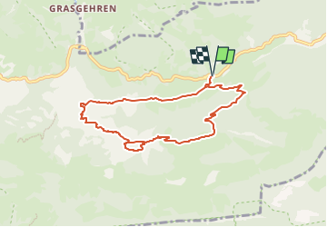
6,4 km | 9,8 km-effort
2h 14min
Non
Randonnée A pied Oberstdorf - Ro - Ins winterliche Rohrmoos - Photo
A pied
PRO

A pied

Facile
Oberstdorf, Bavière, Landkreis Oberallgäu, Allemagne
6,4 km | 7,8 km-effort
1h 46min
Non
Randonnée Marche Oberstdorf - Duitsland - Breitachklamm - Photo
Marche
gpstracks

Marche

Très facile
Oberstdorf, Bavière, Landkreis Oberallgäu, Allemagne
4,8 km | 7,9 km-effort
Inconnu
Oui
Randonnée Marche Bolsterlang - Duitsland - Bolsterlang-Ofterschwang - Photo
Marche
gpstracks

Marche

Très facile
Bolsterlang, Bavière, Landkreis Oberallgäu, Allemagne
13,5 km | 25 km-effort
Inconnu
Oui


Fermer
Mes abonnements