Randonnée A pied Püttlingen - Pfarrer-Rug-Weg - Photo

Tous les sentiers balisés d’Europe PRO

© OpenStreetMap contributors
Longueur
Longueur
41 km
Altitude max
Altitude max
400 m
Dénivelé positif
Dénivelé positif
987 m
Km-Effort
Km-Effort  
54 km
Altitude min
Altitude min
201 m
Dénivelé négatif
Dénivelé négatif
986 m
Boucle
Boucle
Oui
Balise
Balise
Date de création :
2022-02-11 17:46:43.639
Dernière modification :
2022-02-11 17:46:43.639

(0 Avis)

A pied
A pied
12h15
Difficulté : Très difficile

Scannez ce code QR pour ouvrir la randonnée dans l'application SityTrail

Application GPS de randonnée GRATUITE

Logo SityTrail SityTrail

IGN / Instituts géographiques

Télécharger SityTrail sur l'App Store Télécharger SityTrail sur Google Play

Logo SityTrail SityTrail World

Le monde est à vous

Télécharger SityTrail sur l'App Store Télécharger SityTrail sur Google Play Télécharger SityTrail sur Huawei AppGallery

À propos

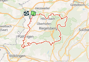
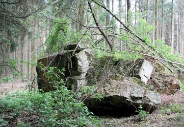
Randonnée A pied de 41 km à découvrir à Sarre, Regionalverband Saarbrücken, Püttlingen. Cette randonnée est proposée par SityTrail - itinéraires balisés pédestres.

Description

Eurodistrict SaarMoselle

Site web: http://www.vianovis.net/saarmoselle/#SOURCE=saarmoselle-touren&FID=64&m=satellite&zoomto=true

Photos

Localisation

Pays :
Allemagne
Région :
Sarre
Département/Province :
Regionalverband Saarbrücken
Commune :
Püttlingen
Localité :
Köllerbach
Départ:(UTM)
347093 ; 5465064 (32U) N.

Randonnées à proximité

Randonnée A pied Püttlingen - Haldenrundweg Südschleife - Photo
A pied
PRO

A pied

Facile
Püttlingen, Sarre, Regionalverband Saarbrücken, Allemagne
9,8 km | 12,2 km-effort
2h 45min
Non
Randonnée A pied Sarrebruck - Milanweg - Photo
A pied
PRO

A pied

Facile
Sarrebruck, Sarre, Regionalverband Saarbrücken, Allemagne
5,3 km | 6,7 km-effort
1h 30min
Non
Randonnée A pied Riegelsberg - Frohn-Wald-Weg - Photo
A pied
PRO

A pied

Facile
Riegelsberg, Sarre, Regionalverband Saarbrücken, Allemagne
5,8 km | 7,8 km-effort
1h 46min
Non
Randonnée A pied Schwalbach - Mühlenweg - durch das Sprenger Bachtal - Photo
A pied
PRO

A pied

Facile
Schwalbach, Sarre, Landkreis Saarlouis, Allemagne
7,9 km | 8,8 km-effort
2h 0min
Non
Randonnée A pied Heusweiler - Grenzsteinwanderweg - Photo
A pied
PRO

A pied

Facile
Heusweiler, Sarre, Regionalverband Saarbrücken, Allemagne
14,6 km | 18,6 km-effort
4h 13min
Non
Randonnée Autre activité Püttlingen - vosges3 - Photo
Autre activité
froggymix

Autre activité

Très facile
Püttlingen, Sarre, Regionalverband Saarbrücken, Allemagne
551 km | 728 km-effort
Inconnu
Non


Fermer
Mes abonnements