![](/images/other/stat-length.png)
![Randonnée A pied Gomadingen - hochgehschätzt - Photo](https://media.geolcdn.com/t/1900/400/ext.pjpeg?maxdim=2&url=https%3A%2F%2Fmedia.geolcdn.com%2Ff%2F2d6c90c8-519d-43f8-977e-d2d00fe2bd1e.jpeg)
hochgehschätzt
SityTrail - itinéraires balisés pédestres
Tous les sentiers balisés d’Europe PRO
![Longueur](/images/other/stat-length.png)
Longueur
4,7 km
![Altitude max](https://static1.geolcdn.com/siteimages/upload/files/1508320355ic_sort_altitude_max_24dp.png)
Altitude max
674 m
![Dénivelé positif](https://static1.geolcdn.com/siteimages/upload/files/1508320355ic_sort_den_pos_24dp.png)
Dénivelé positif
56 m
![Km-Effort](/images/other/stat-length.png)
Km-Effort
5,7 km
![Altitude min](https://static1.geolcdn.com/siteimages/upload/files/1508320355ic_sort_altitude_min_24dp.png)
Altitude min
573 m
![Dénivelé négatif](https://static1.geolcdn.com/siteimages/upload/files/1508320355ic_sort_den_neg_24dp.png)
Dénivelé négatif
148 m
![Boucle](https://static1.geolcdn.com/siteimages/upload/files/16400158638029165_repeat_loop_refresh_sync_direction_icon.png)
Boucle
Non
Balise
Date de création :
2022-02-11 20:47:28.968
Dernière modification :
2022-02-11 20:47:28.968
![A pied](https://static1.geolcdn.com/sitytour/trail-icons/100.png)
1h17
Difficulté : Facile
![Scannez ce code QR pour ouvrir la randonnée dans l'application SityTrail](https://capi.geolives.com/qq0zvz2zws4bq2lad0pu/sitytour/trails/3102212/qr.png?size=200)
Application GPS de randonnée GRATUITE
À propos
Randonnée A pied de 4,7 km à découvrir à Bade-Wurtemberg, Landkreis Reutlingen, Gomadingen. Cette randonnée est proposée par SityTrail - itinéraires balisés pédestres.
Description
Randonnée créée par Wanderregion »hochgehberge«.
Site web: https://hochgehberge.de/touren/hochgehschaetzt-premiumwanderweg-hayingen-glastal/
Localisation
Pays :
Allemagne
Région :
Bade-Wurtemberg
Département/Province :
Landkreis Reutlingen
Commune :
Gomadingen
Localité :
Unknown
Départ:(Dec)
Départ:(UTM)
534015 ; 5347417 (32U) N.
Commentaires
Randonnées à proximité
![Randonnée A pied Gomadingen - hochgehswiggert - Photo](https://media.geolcdn.com/t/375/260/ext.jpg?maxdim=2&url=https%3A%2F%2Fmedia.geolcdn.com%2Ff%2F9083d221-2db2-4dcc-bfb3-5f556f5dd0ca.jpeg)
![A pied A pied](https://static1.geolcdn.com/sitytour/trail-icons/100.png)
hochgehswiggert
A pied
Facile
Gomadingen,
Bade-Wurtemberg,
Landkreis Reutlingen,
Allemagne
![](/images/other/stat-length.png)
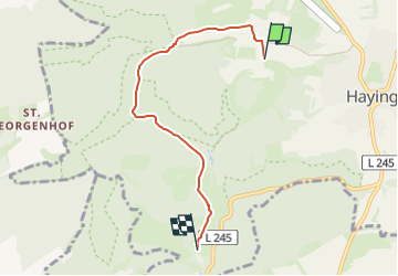
6,7 km | 10,3 km-effort
2h 19min
![](https://static1.geolcdn.com/siteimages/upload/files/16400158638029165_repeat_loop_refresh_sync_direction_icon.png)
Non
![Randonnée A pied Gomadingen - Rose-Rundweg - Photo](https://media.geolcdn.com/t/375/260/ext.jpg?maxdim=2&url=https%3A%2F%2Fmedia.geolcdn.com%2Ff%2F889fb613-b6a9-4485-b124-f8cd332ce1de.jpeg)
![A pied A pied](https://static1.geolcdn.com/sitytour/trail-icons/100.png)
Rose-Rundweg
A pied
Facile
Gomadingen,
Bade-Wurtemberg,
Landkreis Reutlingen,
Allemagne
![](/images/other/stat-length.png)
5,1 km | 6,3 km-effort
1h 26min
![](https://static1.geolcdn.com/siteimages/upload/files/16400158638029165_repeat_loop_refresh_sync_direction_icon.png)
Non
![Randonnée A pied Gomadingen - hochgehlautert - Photo](https://media.geolcdn.com/t/375/260/ext.jpg?maxdim=2&url=https%3A%2F%2Fstatic1.geolcdn.com%2Fsiteimages%2Fupload%2Ffiles%2F1545311037marcheuse_200dpi.jpg)
![A pied A pied](https://static1.geolcdn.com/sitytour/trail-icons/100.png)
hochgehlautert
A pied
Facile
Gomadingen,
Bade-Wurtemberg,
Landkreis Reutlingen,
Allemagne
![](/images/other/stat-length.png)
10,6 km | 14,9 km-effort
3h 23min
![](https://static1.geolcdn.com/siteimages/upload/files/16400158638029165_repeat_loop_refresh_sync_direction_icon.png)
Oui
![Randonnée Marche Gomadingen - w-duitsland-naturtheater-hayingen - Photo](https://media.geolcdn.com/t/375/260/ext.jpg?maxdim=2&url=https%3A%2F%2Fstatic1.geolcdn.com%2Fsiteimages%2Fupload%2Ffiles%2F1553511878bg_sport_marche.png)
![Marche Marche](https://static1.geolcdn.com/sitytour/trail-icons/101.png)
w-duitsland-naturtheater-hayingen
Marche
Très facile
Gomadingen,
Bade-Wurtemberg,
Landkreis Reutlingen,
Allemagne
![](/images/other/stat-length.png)
3,4 km | 4,5 km-effort
Inconnu
![](https://static1.geolcdn.com/siteimages/upload/files/16400158638029165_repeat_loop_refresh_sync_direction_icon.png)
Oui
![Randonnée Marche Gomadingen - w-duitsland-grosse-lauter - Photo](https://media.geolcdn.com/t/375/260/ext.jpg?maxdim=2&url=https%3A%2F%2Fstatic1.geolcdn.com%2Fsiteimages%2Fupload%2Ffiles%2F1553511878bg_sport_marche.png)
![Marche Marche](https://static1.geolcdn.com/sitytour/trail-icons/101.png)
w-duitsland-grosse-lauter
Marche
Très facile
Gomadingen,
Bade-Wurtemberg,
Landkreis Reutlingen,
Allemagne
![](/images/other/stat-length.png)
5,5 km | 7,1 km-effort
Inconnu
![](https://static1.geolcdn.com/siteimages/upload/files/16400158638029165_repeat_loop_refresh_sync_direction_icon.png)
Oui