Randonnée A pied Unknown - Terras da Ordem - Photo

Terras da Ordem

Tous les sentiers balisés d’Europe PRO

© OpenStreetMap contributors
Longueur
Longueur
14,4 km
Altitude max
Altitude max
162 m
Dénivelé positif
Dénivelé positif
324 m
Km-Effort
Km-Effort  
18,7 km
Altitude min
Altitude min
5 m
Dénivelé négatif
Dénivelé négatif
324 m
Boucle
Boucle
Oui
Balise
Balise
Date de création :
2022-02-14 15:19:14.207
Dernière modification :
2022-02-14 15:19:14.207

(0 Avis)

A pied
A pied
4h15
Difficulté : Facile

Scannez ce code QR pour ouvrir la randonnée dans l'application SityTrail

Application GPS de randonnée GRATUITE

Logo SityTrail SityTrail

IGN / Instituts géographiques

Télécharger SityTrail sur l'App Store Télécharger SityTrail sur Google Play

Logo SityTrail SityTrail World

Le monde est à vous

Télécharger SityTrail sur l'App Store Télécharger SityTrail sur Google Play Télécharger SityTrail sur Huawei AppGallery

À propos

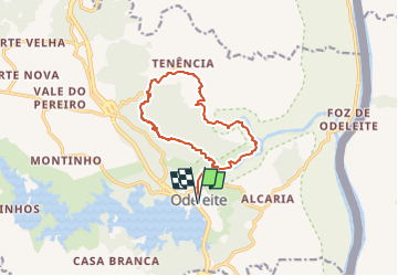
Randonnée A pied de 14,4 km à découvrir à Algarve, Faro. Cette randonnée est proposée par SityTrail - itinéraires balisés pédestres.

Description

Randonnée créée par Câmara Municipal de Castro Marim / Odiana.

Photos

Localisation

Pays :
Portugal
Région :
Algarve
Département/Province :
Faro
Commune :
Unknown
Localité :
Unknown
Départ:(UTM)
633866 ; 4132942 (29S) N.

Randonnées à proximité

Randonnée A pied  - Odeleite de perto e de longe - Photo
A pied
PRO

A pied

Facile
, Algarve, Faro, Portugal
10,4 km | 13,5 km-effort
3h 3min
Oui
Randonnée Marche Odeleite - w-portugal-langs-twee-rivieren - Photo
Marche
gpstracks

Marche

Très facile
Odeleite, Algarve, Faro, Portugal
18,1 km | 22 km-effort
Inconnu
Oui


Fermer
Mes abonnements