Randonnée A pied Rhenen - NS-wandeling Blauwe Kamer - Photo

NS-wandeling Blauwe Kamer

Tous les sentiers balisés d’Europe PRO

© OpenStreetMap contributors
Longueur
Longueur
14,6 km
Altitude max
Altitude max
56 m
Dénivelé positif
Dénivelé positif
147 m
Km-Effort
Km-Effort  
16,6 km
Altitude min
Altitude min
3 m
Dénivelé négatif
Dénivelé négatif
147 m
Boucle
Boucle
Oui
Balise
Balise
Date de création :
2022-02-14 15:29:39.774
Dernière modification :
2022-02-14 15:29:39.774

(0 Avis)

A pied
A pied
3h45
Difficulté : Facile

Scannez ce code QR pour ouvrir la randonnée dans l'application SityTrail

Application GPS de randonnée GRATUITE

Logo SityTrail SityTrail

IGN / Instituts géographiques

Télécharger SityTrail sur l'App Store Télécharger SityTrail sur Google Play

Logo SityTrail SityTrail World

Le monde est à vous

Télécharger SityTrail sur l'App Store Télécharger SityTrail sur Google Play Télécharger SityTrail sur Huawei AppGallery

À propos

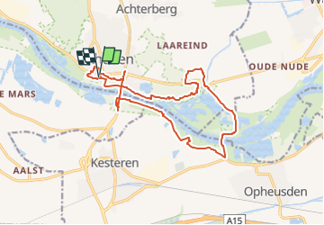
Randonnée A pied de 14,6 km à découvrir à Utrecht, Inconnu, Rhenen. Cette randonnée est proposée par SityTrail - itinéraires balisés pédestres.

Description

Een aaneenschakeling van hoogtepunten: de weidse uiterwaarden van de Nederrijn, natuurgebied de Blauwe Kamer en de Grebbeberg.

Site web: https://www.ns.nl/dagje-uit/wandelen/blauwe-kamer-rhenen.html

Photos

Localisation

Pays :
Pays-Bas
Région :
Utrecht
Département/Province :
Inconnu
Commune :
Rhenen
Localité :
Unknown
Départ:(UTM)
676478 ; 5759338 (31U) N.

Randonnées à proximité

Randonnée A pied Rhenen - Grift en Graftenpad - Photo
A pied
PRO

A pied

Facile
Rhenen, Utrecht, Inconnu, Pays-Bas
11,7 km | 12,9 km-effort
2h 55min
Oui
Randonnée A pied Rhenen - NS-wandeltocht Elsterberg - Photo
A pied
PRO

A pied

Moyen
Rhenen, Utrecht, Inconnu, Pays-Bas
17,7 km | 20 km-effort
4h 38min
Non
Randonnée Marche Rhenen - w-gelderland-rhenen-opheusden - Photo
Marche
gpstracks

Marche

Très facile
(1)
Rhenen, Utrecht, Inconnu, Pays-Bas
12 km | 13,2 km-effort
Inconnu
Oui
Randonnée Marche Rhenen - Utrecht - wandeling Rondje Grebbeberg - Photo
Marche
gpstracks

Marche

Très facile
(1)
Rhenen, Utrecht, Inconnu, Pays-Bas
7,9 km | 9,1 km-effort
Inconnu
Oui
Randonnée Marche Rhenen - Rondje Nederrijn - Photo
Marche
roelvdh

Marche

Facile
Rhenen, Utrecht, Inconnu, Pays-Bas
10 km | 11,2 km-effort
Inconnu
Oui
Randonnée Vélo Rhenen - Utrecht - Griftvalleiroute - Photo
Vélo
gpstracks

Vélo

Très facile
Rhenen, Utrecht, Inconnu, Pays-Bas
23 km | 26 km-effort
Inconnu
Oui
Randonnée Vélo Rhenen - Utrecht - betuwe heuvelrug route - Photo
Vélo
gpstracks

Vélo

Très facile
Rhenen, Utrecht, Inconnu, Pays-Bas
65 km | 70 km-effort
Inconnu
Oui
Randonnée Vélo Neder-Betuwe - Gelderland - Midden-Betuwe - Photo
Vélo
gpstracks

Vélo

Très facile
Neder-Betuwe, Gueldre, Inconnu, Pays-Bas
47 km | 50 km-effort
Inconnu
Oui
Randonnée Vélo Neder-Betuwe - f-zholland-limes-katwijk-nijmegen - Photo
Vélo
gpstracks

Vélo

Très facile
Neder-Betuwe, Gueldre, Inconnu, Pays-Bas
271 km | 285 km-effort
Inconnu
Non


Fermer
Mes abonnements