Randonnée Marche Viéville-en-Haye - circuit des Rappes - Photo
 kikkko
kikkko

Utilisateur

© OpenStreetMap contributors
Longueur
Longueur
13,6 km
Altitude max
Altitude max
348 m
Dénivelé positif
Dénivelé positif
165 m
Km-Effort
Km-Effort  
16,2 km
Altitude min
Altitude min
206 m
Dénivelé négatif
Dénivelé négatif
299 m
Boucle
Boucle
Non
Date de création :
2022-03-18 07:53:24.787
Dernière modification :
2022-03-18 10:49:12.994

(0 Avis)

Marche
Marche
2h33
Difficulté : Facile

Scannez ce code QR pour ouvrir la randonnée dans l'application SityTrail

Application GPS de randonnée GRATUITE

Logo SityTrail SityTrail

IGN / Instituts géographiques

Télécharger SityTrail sur l'App Store Télécharger SityTrail sur Google Play

Logo SityTrail SityTrail World

Le monde est à vous

Télécharger SityTrail sur l'App Store Télécharger SityTrail sur Google Play Télécharger SityTrail sur Huawei AppGallery

À propos

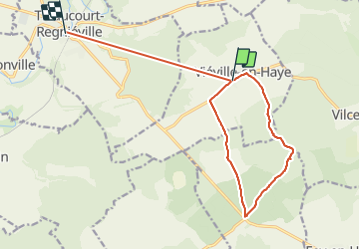
Randonnée Marche de 13,6 km à découvrir à Grand Est, Meurthe-et-Moselle, Viéville-en-Haye. Cette randonnée est proposée par kikkko.

Description

Balisé rond bleu
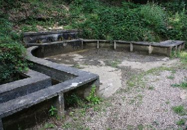
fontaine des 4 Goulots
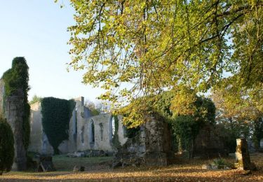
Abris de la guerre

Profil altimétrique

Localisation

Pays :
France
Région :
Grand Est
Département/Province :
Meurthe-et-Moselle
Commune :
Viéville-en-Haye
Localité :
Unknown
Départ:(UTM)
714088 ; 5425064 (31U) N.

Randonnées à proximité

Randonnée V.T.T. Vilcey-sur-Trey - Les villages du Saillant de St-Mihiel, aux portes de Pontà-Mousson. - Circuit n° 12 - Photo
V.T.T.
tracegps

V.T.T.

Difficile
Vilcey-sur-Trey, Grand Est, Meurthe-et-Moselle, France
47 km | 56 km-effort
2h 30min
Oui
Randonnée Vélo Jaulny - La vallée du Rupt de Mad - Circuit n° 14 - Jaulny - Photo
Vélo
tracegps

Vélo

Facile
Jaulny, Grand Est, Meurthe-et-Moselle, France
19,1 km | 22 km-effort
1h 0min
Oui
Randonnée Vélo Thiaucourt-Regniéville - Les paysages de l'Histoire (option Flirey) - Circuit n° 13 - Photo
Vélo
tracegps

Vélo

Difficile
Thiaucourt-Regniéville, Grand Est, Meurthe-et-Moselle, France
60 km | 68 km-effort
3h 0min
Oui
Randonnée Vélo Thiaucourt-Regniéville - Les paysages de l'Histoire - Circuit n° 13 - Thiaucourt Regniéville - Photo
Vélo
tracegps

Vélo

Moyen
Thiaucourt-Regniéville, Grand Est, Meurthe-et-Moselle, France
49 km | 56 km-effort
2h 30min
Oui
Randonnée Marche Prény - Cabane Vautrin - Photo
Marche
bitiba

Marche

Moyen
Prény, Grand Est, Meurthe-et-Moselle, France
5,6 km | 6,7 km-effort
1h 32min
Oui
Randonnée Marche Vilcey-sur-Trey - Vilcey sur Trey - Photo
Marche
Greg813

Marche

Difficile
Vilcey-sur-Trey, Grand Est, Meurthe-et-Moselle, France
17,2 km | 22 km-effort
4h 50min
Oui
Randonnée V.T.T. Thiaucourt-Regniéville - Thiaucourt Jaulny Rembercourt - Photo
V.T.T.
kikkko

V.T.T.

Facile
Thiaucourt-Regniéville, Grand Est, Meurthe-et-Moselle, France
16,9 km | 21 km-effort
1h 36min
Oui
Randonnée Marche Prény - Tour pour circuit tour - Photo
Marche
bitiba

Marche

Moyen
Prény, Grand Est, Meurthe-et-Moselle, France
6,1 km | 7 km-effort
1h 43min
Oui
Randonnée V.T.T. Thiaucourt-Regniéville - sortie de thaucourd ctm - Photo
V.T.T.
nouga

V.T.T.

Difficile
Thiaucourt-Regniéville, Grand Est, Meurthe-et-Moselle, France
26 km | 31 km-effort
2h 30min
Oui


Fermer
Mes abonnements