


ROCHE DES BRUYERES

surceneux
Utilisateur
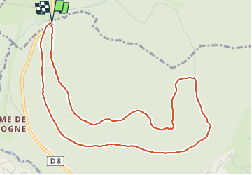

Longueur
5,7 km

Altitude max
971 m

Dénivelé positif
190 m
Km-Effort
8,2 km

Altitude min
801 m

Dénivelé négatif
180 m
Boucle
Oui
Date de création :
2022-03-27 12:39:38.249
Dernière modification :
2022-03-27 14:25:20.009
1h15
Difficulté : Très facile

Application GPS de randonnée GRATUITE
 SityTrail
IGN / Instituts géographiques
SityTrail Plus
Le monde est à vous
À propos
Randonnée Marche de 5,7 km à découvrir à Grand Est, Vosges, Xonrupt-Longemer. Cette randonnée est proposée par surceneux.
Description
MARTIMPRE COL BEHEUILLE GILET RECT VERT MARTINPRE
Localisation
Pays :
France
Région :
Grand Est
Département/Province :
Vosges
Commune :
Xonrupt-Longemer
Localité :
Unknown
Départ:(Dec)
Départ:(UTM)
344032 ; 5329339 (32U) N.
Commentaires