


mirmande

micheleuvrard
Utilisateur
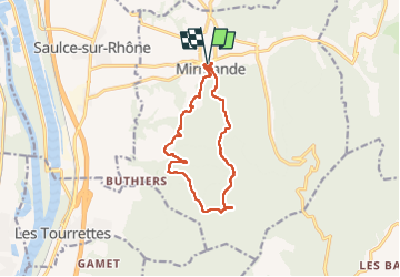

Longueur
12,3 km

Altitude max
452 m

Dénivelé positif
399 m
Km-Effort
17,6 km

Altitude min
172 m

Dénivelé négatif
397 m
Boucle
Oui
Date de création :
2022-04-14 08:01:30.997
Dernière modification :
2022-04-14 13:35:04.782
5h31
Difficulté : Difficile

Application GPS de randonnée GRATUITE
 SityTrail
IGN / Instituts géographiques
SityTrail Plus
Le monde est à vous
À propos
Randonnée Marche de 12,3 km à découvrir à Auvergne-Rhône-Alpes, Drôme, Mirmande. Cette randonnée est proposée par micheleuvrard.
Localisation
Pays :
France
Région :
Auvergne-Rhône-Alpes
Département/Province :
Drôme
Commune :
Mirmande
Localité :
Unknown
Départ:(Dec)
Départ:(UTM)
645389 ; 4951202 (31T) N.
Commentaires