


wiclow

peuch4
Utilisateur
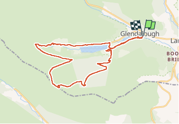

Longueur
18 km

Altitude max
603 m

Dénivelé positif
641 m
Km-Effort
27 km

Altitude min
128 m

Dénivelé négatif
640 m
Boucle
Oui
Date de création :
2022-04-14 10:38:37.718
Dernière modification :
2022-04-17 06:35:44.621
4h11
Difficulté : Très difficile

Application GPS de randonnée GRATUITE
 SityTrail
IGN / Instituts géographiques
SityTrail Plus
Le monde est à vous
À propos
Randonnée Marche de 18 km à découvrir à Inconnu, County Wicklow, The Municipal District of Wicklow. Cette randonnée est proposée par peuch4.
Localisation
Pays :
Irlande
Région :
Inconnu
Département/Province :
County Wicklow
Commune :
The Municipal District of Wicklow
Localité :
Brockagh
Départ:(Dec)
Départ:(UTM)
679556 ; 5876774 (29U) N.
Commentaires