![](/images/other/stat-length.png)
![Randonnée Marche Saint-Paul - La Réunion - Grand Bénard par le Maïdo - Photo](https://media.geolcdn.com/t/1900/400/ext.pjpeg?maxdim=2&url=https%3A%2F%2Fservices.sitytrail.com%2FGeolivesWS%2FDownloadMedia.ashx%3FTrailID%3D321056%26Media%3Dfix__20140705111632.jpg)
La Réunion - Grand Bénard par le Maïdo
olive2b
Utilisateur
![Longueur](/images/other/stat-length.png)
Longueur
19 km
![Altitude max](https://static1.geolcdn.com/siteimages/upload/files/1508320355ic_sort_altitude_max_24dp.png)
Altitude max
2895 m
![Dénivelé positif](https://static1.geolcdn.com/siteimages/upload/files/1508320355ic_sort_den_pos_24dp.png)
Dénivelé positif
812 m
![Km-Effort](/images/other/stat-length.png)
Km-Effort
30 km
![Altitude min](https://static1.geolcdn.com/siteimages/upload/files/1508320355ic_sort_altitude_min_24dp.png)
Altitude min
2155 m
![Dénivelé négatif](https://static1.geolcdn.com/siteimages/upload/files/1508320355ic_sort_den_neg_24dp.png)
Dénivelé négatif
811 m
![Boucle](https://static1.geolcdn.com/siteimages/upload/files/16400158638029165_repeat_loop_refresh_sync_direction_icon.png)
Boucle
Oui
Date de création :
2016-03-09 00:00:00.0
Dernière modification :
2016-03-09 00:00:00.0
![Marche](https://static1.geolcdn.com/sitytour/trail-icons/101.png)
4h17
Difficulté : Moyen
![Scannez ce code QR pour ouvrir la randonnée dans l'application SityTrail](https://capi.geolives.com/qq0zvz2zws4bq2lad0pu/sitytour/trails/321056/qr.png?size=200)
Application GPS de randonnée GRATUITE
À propos
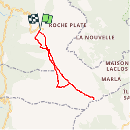
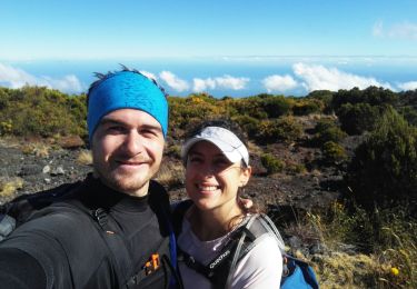
Randonnée Marche de 19 km à découvrir à La Réunion, Inconnu, Saint-Paul. Cette randonnée est proposée par olive2b.
Description
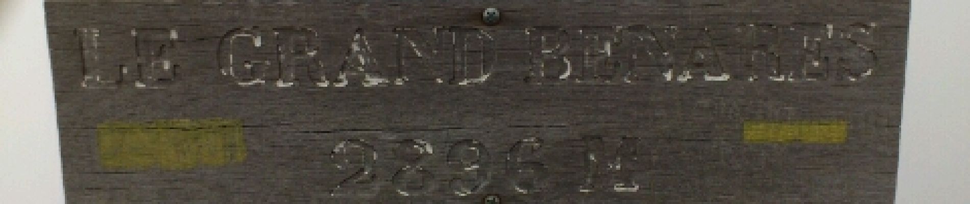
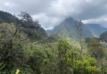
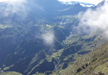
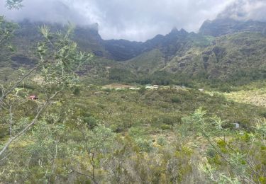
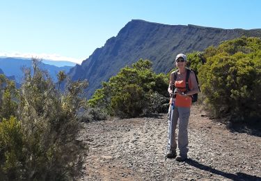
Circuit aller. Passage par "le Grand Bord". Vue magnifique sur le cirque de Mafate. A la fin, vue du cirque de Mafate, et Cilaos.
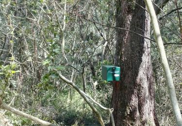
Localisation
Pays :
France
Région :
La Réunion
Département/Province :
Inconnu
Commune :
Saint-Paul
Localité :
Unknown
Départ:(Dec)
Départ:(UTM)
332323 ; 7669029 (40K) S.
Commentaires
Randonnées à proximité
![Randonnée Marche La Possession - 2023 11 15 Marlat au parking - réalisé - Photo](https://media.geolcdn.com/t/375/260/ext.jpg?maxdim=2&url=https%3A%2F%2Fmedia.geolcdn.com%2Ff%2F093af69e-78fe-41c7-acee-69db22f464ab.jpg)
![Marche Marche](https://static1.geolcdn.com/sitytour/trail-icons/101.png)
2023 11 15 Marlat au parking - réalisé
Marche
Difficile
(1)
La Possession,
La Réunion,
Inconnu,
France
![](/images/other/stat-length.png)
10,1 km | 16,7 km-effort
4h 47min
![](https://static1.geolcdn.com/siteimages/upload/files/16400158638029165_repeat_loop_refresh_sync_direction_icon.png)
Non
![Randonnée Marche Saint-Paul - Descente du Maïdo vers Les Orangers - Photo](https://media.geolcdn.com/t/375/260/ext.jpg?maxdim=2&url=https%3A%2F%2Fstatic1.geolcdn.com%2Fsiteimages%2Fupload%2Ffiles%2F1553511878bg_sport_marche.png)
![Marche Marche](https://static1.geolcdn.com/sitytour/trail-icons/101.png)
Descente du Maïdo vers Les Orangers
Marche
Difficile
(2)
Saint-Paul,
La Réunion,
Inconnu,
France
![](/images/other/stat-length.png)
6,7 km | 13,3 km-effort
3h 12min
![](https://static1.geolcdn.com/siteimages/upload/files/16400158638029165_repeat_loop_refresh_sync_direction_icon.png)
Non
![Randonnée Marche Saint-Paul - Maido - Grand Benare - Glacière - Photo](https://media.geolcdn.com/t/375/260/ext.jpg?maxdim=2&url=https%3A%2F%2Fservices.sitytrail.com%2FGeolivesWS%2FDownloadMedia.ashx%3FTrailID%3D388805%26Media%3D1deddf74-db33-4821-b559-f855fd7e2315.jpg)
![Marche Marche](https://static1.geolcdn.com/sitytour/trail-icons/101.png)
Maido - Grand Benare - Glacière
Marche
Moyen
(3)
Saint-Paul,
La Réunion,
Inconnu,
France
![](/images/other/stat-length.png)
16,6 km | 27 km-effort
2h 58min
![](https://static1.geolcdn.com/siteimages/upload/files/16400158638029165_repeat_loop_refresh_sync_direction_icon.png)
Oui
![Randonnée Marche Saint-Paul - Le grand benare - Photo](https://media.geolcdn.com/t/375/260/ext.jpg?maxdim=2&url=https%3A%2F%2Fstatic1.geolcdn.com%2Fsiteimages%2Fupload%2Ffiles%2F1553511878bg_sport_marche.png)
![Marche Marche](https://static1.geolcdn.com/sitytour/trail-icons/101.png)
Le grand benare
Marche
Moyen
(1)
Saint-Paul,
La Réunion,
Inconnu,
France
![](/images/other/stat-length.png)
16,5 km | 27 km-effort
5h 44min
![](https://static1.geolcdn.com/siteimages/upload/files/16400158638029165_repeat_loop_refresh_sync_direction_icon.png)
Oui
![Randonnée Marche La Possession - 2023 11 Réalisée - Photo](https://media.geolcdn.com/t/375/260/ext.jpg?maxdim=2&url=https%3A%2F%2Fmedia.geolcdn.com%2Ff%2F05dfd58c-18ed-415c-b21e-7ce5c9e44bf9.jpg)
![Marche Marche](https://static1.geolcdn.com/sitytour/trail-icons/101.png)
2023 11 Réalisée
Marche
Très difficile
La Possession,
La Réunion,
Inconnu,
France
![](/images/other/stat-length.png)
14 km | 29 km-effort
8h 8min
![](https://static1.geolcdn.com/siteimages/upload/files/16400158638029165_repeat_loop_refresh_sync_direction_icon.png)
Non
![Randonnée Marche Saint-Paul - Grand Bénare depuis le Maïdo - Photo](https://media.geolcdn.com/t/375/260/ext.jpg?maxdim=2&url=https%3A%2F%2Fmedia.geolcdn.com%2Ff%2F6215cd81-23c1-4510-b5c6-f139b8d4e0b0.jpg)
![Marche Marche](https://static1.geolcdn.com/sitytour/trail-icons/101.png)
Grand Bénare depuis le Maïdo
Marche
Moyen
Saint-Paul,
La Réunion,
Inconnu,
France
![](/images/other/stat-length.png)
19,6 km | 33 km-effort
5h 33min
![](https://static1.geolcdn.com/siteimages/upload/files/16400158638029165_repeat_loop_refresh_sync_direction_icon.png)
Oui
![Randonnée Marche La Possession - grand place la nouvelle - Photo](https://media.geolcdn.com/t/375/260/ext.jpg?maxdim=2&url=https%3A%2F%2Fmedia.geolcdn.com%2Ff%2F04480c93-eabe-4d3e-95a1-2ed8fc91883e.jpg)
![Marche Marche](https://static1.geolcdn.com/sitytour/trail-icons/101.png)
grand place la nouvelle
Marche
Très difficile
La Possession,
La Réunion,
Inconnu,
France
![](/images/other/stat-length.png)
27 km | 72 km-effort
9h 48min
![](https://static1.geolcdn.com/siteimages/upload/files/16400158638029165_repeat_loop_refresh_sync_direction_icon.png)
Non
![Randonnée Marche Saint-Paul - Grand Benare - Photo](https://media.geolcdn.com/t/375/260/ext.jpg?maxdim=2&url=https%3A%2F%2Fmedia.geolcdn.com%2Ff%2F3036134d-2f58-40f2-b890-f95978cf611e.jpg)
![Marche Marche](https://static1.geolcdn.com/sitytour/trail-icons/101.png)
Grand Benare
Marche
Très difficile
Saint-Paul,
La Réunion,
Inconnu,
France
![](/images/other/stat-length.png)
11,2 km | 20 km-effort
5h 8min
![](https://static1.geolcdn.com/siteimages/upload/files/16400158638029165_repeat_loop_refresh_sync_direction_icon.png)
Non
![Randonnée Marche La Possession - Retour au col des Bœufs depuis Marla - Photo](https://media.geolcdn.com/t/375/260/ext.jpg?maxdim=2&url=https%3A%2F%2Fmedia.geolcdn.com%2Ff%2F5c26a42b-9e4b-443c-ba55-6932a3b794df.jpg)
![Marche Marche](https://static1.geolcdn.com/sitytour/trail-icons/101.png)
Retour au col des Bœufs depuis Marla
Marche
Moyen
La Possession,
La Réunion,
Inconnu,
France
![](/images/other/stat-length.png)
7,7 km | 14 km-effort
2h 46min
![](https://static1.geolcdn.com/siteimages/upload/files/16400158638029165_repeat_loop_refresh_sync_direction_icon.png)
Non