Randonnée Marche Livarot-Pays-d'Auge -  Traditional Cache #1 Fêtons nos 2000 !!! par nounou1437 - Photo

Traditional Cache #1 Fêtons nos 2000 !!! par nounou1437

 yannick-p
yannick-p

Utilisateur

© OpenStreetMap contributors
Longueur
Longueur
7 km
Altitude max
Altitude max
223 m
Dénivelé positif
Dénivelé positif
135 m
Km-Effort
Km-Effort  
8,8 km
Altitude min
Altitude min
111 m
Dénivelé négatif
Dénivelé négatif
136 m
Boucle
Boucle
Oui
Date de création :
2022-04-21 21:14:38.961
Dernière modification :
2022-04-21 21:20:58.452

(0 Avis)

Marche
Marche
2h00
Difficulté : Moyen
V.T.T.
V.T.T.
36m
Difficulté : Facile
Geocaching
Geocaching
5h00
Difficulté : Moyen

Scannez ce code QR pour ouvrir la randonnée dans l'application SityTrail

Application GPS de randonnée GRATUITE

Logo SityTrail SityTrail

IGN / Instituts géographiques

Télécharger SityTrail sur l'App Store Télécharger SityTrail sur Google Play

Logo SityTrail SityTrail World

Le monde est à vous

Télécharger SityTrail sur l'App Store Télécharger SityTrail sur Google Play Télécharger SityTrail sur Huawei AppGallery

À propos

Randonnée Marche de 7 km à découvrir à Normandie, Calvados, Livarot-Pays-d'Auge. Cette randonnée est proposée par yannick-p.

Description

Un petit circuit d'une trentaine de caches, une belle série proposée.

Profil altimétrique

Localisation

Pays :
France
Région :
Normandie
Département/Province :
Calvados
Commune :
Livarot-Pays-d'Auge
Localité :
Unknown
Départ:(UTM)
287354 ; 5425931 (31U) N.

Randonnées à proximité

Randonnée Marche Saint-Pierre-en-Auge - Saint Georges en Auge - Photo
Marche
Roulland

Marche

Facile
Saint-Pierre-en-Auge, Normandie, Calvados, France
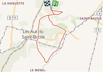
16,1 km | 21 km-effort
3h 33min
Oui
Randonnée A pied Saint-Pierre-en-Auge - Panorama sur l'Oudon - Photo
A pied
PRO

A pied

Facile
Saint-Pierre-en-Auge, Normandie, Calvados, France
12,7 km | 16,3 km-effort
3h 42min
Oui
Randonnée Geocaching Saint-Pierre-en-Auge - Géo-rando # 1 La petite vadrouille  - Photo
Geocaching
yannick-p

Geocaching

Moyen
Saint-Pierre-en-Auge, Normandie, Calvados, France
5,4 km | 6,8 km-effort
3h 30min
Oui
Randonnée 4x4 Vimoutiers - Sortie 21 septembre 2019 - Photo
4x4
Belloche

4x4

Difficile
Vimoutiers, Normandie, Orne, France
60 km | 77 km-effort
4h 48min
Non
Randonnée Marche Saint-Pierre-en-Auge - Vallée de l'Oudon - Photo
Marche
phi14

Marche

Facile
(1)
Saint-Pierre-en-Auge, Normandie, Calvados, France
12,9 km | 16,4 km-effort
3h 11min
Oui
Randonnée Marche Crouttes - crouttes2017 - Photo
Marche
floup6138

Marche

Moyen
Crouttes, Normandie, Orne, France
11,2 km | 15,5 km-effort
2h 39min
Oui
Randonnée Geocaching Saint-Pierre-en-Auge - Les bois d'Ecots 3 - Photo
Geocaching
yannick-p

Geocaching

Moyen
Saint-Pierre-en-Auge, Normandie, Calvados, France
6 km | 7,9 km-effort
2h 0min
Oui
Randonnée V.T.T. Saint-Pierre-en-Auge - Randonnée VTT Le Billot du 16/05/2010 22Km - Photo
V.T.T.
tracegps

V.T.T.

Difficile
Saint-Pierre-en-Auge, Normandie, Calvados, France
21 km | 27 km-effort
2h 0min
Oui
Randonnée Marche Saint-Pierre-en-Auge - la fromagère Le Billot - Photo
Marche
Eve - Line

Marche

Très difficile
Saint-Pierre-en-Auge, Normandie, Calvados, France
20 km | 25 km-effort
4h 3min
Oui


Fermer
Mes abonnements