


Hanches Raizeux poigny repérage

topophil
Utilisateur
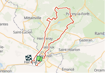

Longueur
33 km

Altitude max
183 m

Dénivelé positif
371 m
Km-Effort
38 km

Altitude min
109 m

Dénivelé négatif
372 m
Boucle
Non
Date de création :
2022-04-24 07:09:34.649
Dernière modification :
2022-04-24 10:24:33.441
3h14
Difficulté : Difficile

Application GPS de randonnée GRATUITE
 SityTrail
IGN / Instituts géographiques
SityTrail Plus
Le monde est à vous
À propos
Randonnée V.T.T. de 33 km à découvrir à Centre-Val de Loire, Eure-et-Loir, Hanches. Cette randonnée est proposée par topophil.
Localisation
Pays :
France
Région :
Centre-Val de Loire
Département/Province :
Eure-et-Loir
Commune :
Hanches
Localité :
Unknown
Départ:(Dec)
Départ:(UTM)
400711 ; 5383394 (31U) N.
Commentaires