


2022-04-30

Lucquiaud
Utilisateur
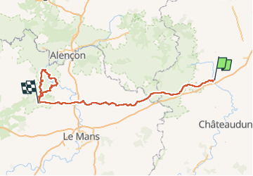

Longueur
216 km

Altitude max
268 m

Dénivelé positif
2869 m
Km-Effort
255 km

Altitude min
53 m

Dénivelé négatif
2859 m
Boucle
Non
Date de création :
2022-04-28 15:53:23.748
Dernière modification :
2022-04-30 19:05:22.717
48h33
Difficulté : Très difficile

Application GPS de randonnée GRATUITE
 SityTrail
IGN / Instituts géographiques
SityTrail Plus
Le monde est à vous
À propos
Randonnée V.T.T. de 216 km à découvrir à Centre-Val de Loire, Eure-et-Loir, Illiers-Combray. Cette randonnée est proposée par Lucquiaud.
Localisation
Pays :
France
Région :
Centre-Val de Loire
Département/Province :
Eure-et-Loir
Commune :
Illiers-Combray
Localité :
Unknown
Départ:(Dec)
Départ:(UTM)
369828 ; 5351555 (31U) N.
Commentaires