Randonnée Marche Stosswihr - Stosswihr L'Altenberg Le Sentier des Roches - Photo

Stosswihr L'Altenberg Le Sentier des Roches

 oscar1
oscar1

Utilisateur

© OpenStreetMap contributors
Longueur
Longueur
16,5 km
Altitude max
Altitude max
1244 m
Dénivelé positif
Dénivelé positif
840 m
Km-Effort
Km-Effort  
28 km
Altitude min
Altitude min
489 m
Dénivelé négatif
Dénivelé négatif
839 m
Boucle
Boucle
Oui
Date de création :
2022-05-11 07:03:00.801
Dernière modification :
2024-03-09 18:12:20.718

(0 Avis)

Marche
Marche
5h31
Difficulté : Très difficile

Scannez ce code QR pour ouvrir la randonnée dans l'application SityTrail

Application GPS de randonnée GRATUITE

Logo SityTrail SityTrail

IGN / Instituts géographiques

Télécharger SityTrail sur l'App Store Télécharger SityTrail sur Google Play

Logo SityTrail SityTrail World

Le monde est à vous

Télécharger SityTrail sur l'App Store Télécharger SityTrail sur Google Play Télécharger SityTrail sur Huawei AppGallery

À propos

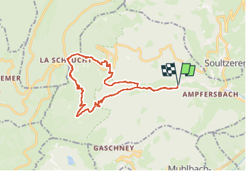
Randonnée Marche de 16,5 km à découvrir à Grand Est, Haut-Rhin, Stosswihr. Cette randonnée est proposée par oscar1.

Description

Au départ de Stosswihr montée raide jusqu'à l'Altenberg. Très belle vue au Spitzenfels. Sentier des Roches, il ne faut pas avoir de vertiges et surtout être bien équipé. Les cascades au Stolz Ablass sont à voir. Belle randonnée pour marcheur aguerri

Profil altimétrique

Photos

Localisation

Pays :
France
Région :
Grand Est
Département/Province :
Haut-Rhin
Commune :
Stosswihr
Localité :
Unknown
Départ:(UTM)
356867 ; 5324242 (32U) N.

Randonnées à proximité

Randonnée Marche Stosswihr - Tour du belvedere avec le passage sur les crêtes  - Photo
Marche
ocepee

Marche

Très facile
(2)
Stosswihr, Grand Est, Haut-Rhin, France
8,5 km | 0 m-effort
2h 28min
Oui
Randonnée Autre activité Soultzeren - Totom 4 lacs - Photo
Autre activité
dinozore

Autre activité

Moyen
(1)
Soultzeren, Grand Est, Haut-Rhin, France
15,6 km | 26 km-effort
4h 37min
Oui
Randonnée Marche Munster - De Munster aux 3 Fours (Aller) - Munster - Photo
Marche
tracegps

Marche

Difficile
(1)
Munster, Grand Est, Haut-Rhin, France
14,8 km | 27 km-effort
5h 0min
Non
Randonnée Marche Hohrod - Circuit historique 1914-18 Hohrodberg - Linge - Photo
Marche
VacheKiri67

Marche

Moyen
(1)
Hohrod, Grand Est, Haut-Rhin, France
14 km | 19,8 km-effort
5h 50min
Oui
Randonnée Marche Le Valtin - Les Hirschsteine - Photo
Marche
VacheKiri67

Marche

Difficile
(1)
Le Valtin, Grand Est, Vosges, France
16,1 km | 25 km-effort
6h 28min
Oui
Randonnée Marche La Bresse - Du Hohneck au Kastelberg par les Spietzkoepfe et le Sentier des Névées - Photo
Marche
tracegps

Marche

Très difficile
(3)
La Bresse, Grand Est, Vosges, France
7,6 km | 13,7 km-effort
3h 30min
Oui
Randonnée Marche Munster - 19.06.13.Munster  - Photo
Marche
ROPPJP

Marche

Très facile
(1)
Munster, Grand Est, Haut-Rhin, France
7,3 km | 10,6 km-effort
2h 10min
Oui
Randonnée Marche Soultzeren - Tanet-Gazon du faing par lac vert et retour sommet du Tanet - Photo
Marche
ride-in-Elsass

Marche

Moyen
(1)
Soultzeren, Grand Est, Haut-Rhin, France
10 km | 15,6 km-effort
4h 24min
Oui
Randonnée V.T.T. Metzeral - Sentier des Névés - Photo
V.T.T.
tracegps

V.T.T.

Très difficile
(1)
Metzeral, Grand Est, Haut-Rhin, France
33 km | 52 km-effort
6h 0min
Oui


Fermer
Mes abonnements