


Rando VTT 2022 MJC Dommartin lés RT

Le grand Claude
Utilisateur
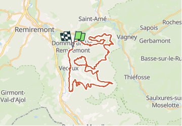

Longueur
41 km

Altitude max
805 m

Dénivelé positif
1376 m
Km-Effort
59 km

Altitude min
389 m

Dénivelé négatif
1379 m
Boucle
Oui
Date de création :
2022-06-05 19:39:14.721
Dernière modification :
2022-06-05 19:51:26.337
4h05
Difficulté : Difficile

Application GPS de randonnée GRATUITE
 SityTrail
IGN / Instituts géographiques
SityTrail Plus
Le monde est à vous
À propos
Randonnée V.T.T. de 41 km à découvrir à Grand Est, Vosges, Dommartin-lès-Remiremont. Cette randonnée est proposée par Le grand Claude.
Description
Grand parcourt EXPERT

Localisation
Pays :
France
Région :
Grand Est
Département/Province :
Vosges
Commune :
Dommartin-lès-Remiremont
Localité :
Unknown
Départ:(Dec)
Départ:(UTM)
324281 ; 5318890 (32T) N.
Commentaires