Randonnée Marche Giverny - BF GIVERNY SityTrail - Photo

BF GIVERNY SityTrail

Marche à la carte

© OpenStreetMap contributors
Longueur
Longueur
7,9 km
Altitude max
Altitude max
143 m
Dénivelé positif
Dénivelé positif
166 m
Km-Effort
Km-Effort  
10,1 km
Altitude min
Altitude min
21 m
Dénivelé négatif
Dénivelé négatif
166 m
Boucle
Boucle
Oui
Date de création :
2022-06-15 07:49:29.667
Dernière modification :
2022-06-19 07:07:18.138

(1 Avis)

Marche
Marche
2h16
Difficulté : Moyen

Scannez ce code QR pour ouvrir la randonnée dans l'application SityTrail

Application GPS de randonnée GRATUITE

Logo SityTrail SityTrail

IGN / Instituts géographiques

Télécharger SityTrail sur l'App Store Télécharger SityTrail sur Google Play

Logo SityTrail SityTrail World

Le monde est à vous

Télécharger SityTrail sur l'App Store Télécharger SityTrail sur Google Play Télécharger SityTrail sur Huawei AppGallery

À propos

Randonnée Marche de 7,9 km à découvrir à Normandie, Eure, Giverny. Cette randonnée est proposée par AMAC.

Profil altimétrique

Localisation

Pays :
France
Région :
Normandie
Département/Province :
Eure
Commune :
Giverny
Localité :
Unknown
Départ:(UTM)
392645 ; 5436891 (31U) N.

Commentaires

Veuillez vous connecter pour laisser un commentaire ou une note


Randonnées à proximité

Randonnée Marche Giverny - 076-104-Giverny Matin 12km-526-030- - Photo
Marche
rvs147

Marche

Facile
(2)
Giverny, Normandie, Eure, France
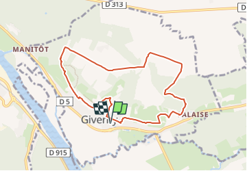
9,2 km | 11,5 km-effort
2h 32min
Oui
Randonnée Marche Vernon - Les falaises de Seine de Vernon à Mantes la Jolie - Photo
Marche
chessyca

Marche

Difficile
Vernon, Normandie, Eure, France
37 km | 47 km-effort
7h 38min
Non
Randonnée Marche Giverny - Giverny Le lézard vert - Photo
Marche
Marie-Claire-mcp

Marche

Difficile
Giverny, Normandie, Eure, France
5,7 km | 7,5 km-effort
1h 57min
Non
Randonnée Marche Giverny - Giverny : les coteaux vers le Vexin 13 km - Photo
Marche
MichelRando7656

Marche

Très facile
Giverny, Normandie, Eure, France
14,7 km | 17,8 km-effort
4h 51min
Non
Randonnée Moteur Giverny - Giverny , les Coteaux avril 2019 - Photo
Moteur
MichelRando7656

Moteur

Moyen
Giverny, Normandie, Eure, France
13,6 km | 16,5 km-effort
3h 28min
Non
Randonnée Moteur Giverny - Giverny , les Coteaux avril 2019 - Photo
Moteur
MichelRando7656

Moteur

Moyen
Giverny, Normandie, Eure, France
13,6 km | 16,5 km-effort
3h 28min
Non
Randonnée Moteur Giverny - Giverny , les Coteaux avril 2019 - Photo
Moteur
MichelRando7656

Moteur

Moyen
Giverny, Normandie, Eure, France
13,6 km | 16,5 km-effort
3h 28min
Non
Randonnée V.T.T. Vernon - Les prés de Vernonnet - Vernon - Photo
V.T.T.
tracegps

V.T.T.

Facile
Vernon, Normandie, Eure, France
3,3 km | 3,7 km-effort
19min
Oui
Randonnée Marche Vernon - Les prés de Vernonnet - Vernon - Photo
Marche
tracegps

Marche

Facile
Vernon, Normandie, Eure, France
3,3 km | 3,7 km-effort
49min
Oui


Fermer
Mes abonnements